IMAGES TAKEN NEAR TO
Cotefield Drive, LEIGHTON BUZZARD, LU7 3DT
Introduction
This page details the photographs taken nearby to Cotefield Drive, LU7 3DT by members of the Geograph project.
The Geograph project started in 2005 with the aim of publishing, organising and preserving representative images for every square kilometre of Great Britain, Ireland and the Isle of Man.

There are currently over 7.5m images from over14,400 individuals and you can help contribute to the project by visiting https://www.geograph.org.uk
Image Map
Images are licensed for reuse under creativecommons.org/licenses/by-sa/2.0
Notes
- Clicking on the map will re-center to the selected point.
- The higher the marker number, the further away the image location is from the centre of the postcode.
Image Listing (7 Images Found)
Images are licensed for reuse under creativecommons.org/licenses/by-sa/2.0
Image
Details
Distance
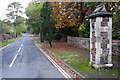
1
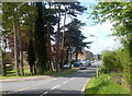
Shenley Hill Road
The edge of town here.
Image: © Des Blenkinsopp
Taken: 6 May 2013
0.10 miles
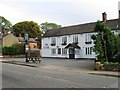
2
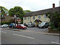
The Star, 230 Heath Road, Leighton Buzzard
Image: © shirokazan
Taken: 26 May 2010
0.16 miles
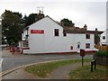
6
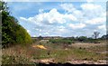
Old Sand Pit on Shenley Hill
One of several large sand quarries which used to work in this area. Now getting overgrown, you can still see a patch of new sand which has been exposed for some reason.
Image: © Des Blenkinsopp
Taken: 6 May 2013
0.22 miles
7
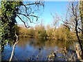
Pond at the roadside, Heath and Reach
Probably a filled in sand pit. The area is covered with old sand-workings.
Image: © Bikeboy
Taken: 16 Feb 2014
0.24 miles