IMAGES TAKEN NEAR TO
Talbot Court, LEIGHTON BUZZARD, LU7 3AA
Introduction
This page details the photographs taken nearby to Talbot Court, LU7 3AA by members of the Geograph project.
The Geograph project started in 2005 with the aim of publishing, organising and preserving representative images for every square kilometre of Great Britain, Ireland and the Isle of Man.

There are currently over 7.5m images from over14,400 individuals and you can help contribute to the project by visiting https://www.geograph.org.uk
Image Map
Images are licensed for reuse under creativecommons.org/licenses/by-sa/2.0
Notes
- Clicking on the map will re-center to the selected point.
- The higher the marker number, the further away the image location is from the centre of the postcode.
Image Listing (9 Images Found)
Images are licensed for reuse under creativecommons.org/licenses/by-sa/2.0
Image
Details
Distance
4
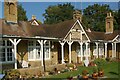
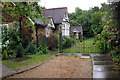
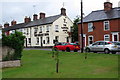
Pages Almshouses, Leighton Buzzard
Pages Almshouses in Church Street were built at a bequest in the will of Councillor William Sharp Page in 1903, costing £1,200 for six almshouses, 'for 2 married couples, 2 single men and 2 widows or spinsters'. Councillor Page also gave a field to be used as a public park to the town.
Image: © Bob Walters
Taken: 27 Sep 2008
0.14 miles