IMAGES TAKEN NEAR TO
Camberton Road, LEIGHTON BUZZARD, LU7 2UN
Introduction
This page details the photographs taken nearby to Camberton Road, LU7 2UN by members of the Geograph project.
The Geograph project started in 2005 with the aim of publishing, organising and preserving representative images for every square kilometre of Great Britain, Ireland and the Isle of Man.

There are currently over 7.5m images from over14,400 individuals and you can help contribute to the project by visiting https://www.geograph.org.uk
Image Map
Images are licensed for reuse under creativecommons.org/licenses/by-sa/2.0
Notes
- Clicking on the map will re-center to the selected point.
- The higher the marker number, the further away the image location is from the centre of the postcode.
Image Listing (105 Images Found)
Images are licensed for reuse under creativecommons.org/licenses/by-sa/2.0
Image
Details
Distance
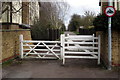
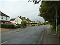
2
Cut through from Mentmore Road into Camberton Road
Image: © Basher Eyre
Taken: 8 Sep 2011
0.07 miles
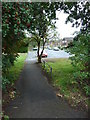
5
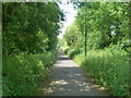
Path along course of old railway
This was the LNWR branch from Leighton Buzzard to Dunstable, closed 1965.
Image: © Robin Webster
Taken: 25 May 2014
0.09 miles
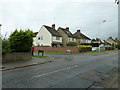
6
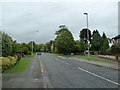
Approaching the junction of Mentmore Road and Camberton Road
Image: © Basher Eyre
Taken: 8 Sep 2011
0.09 miles
7
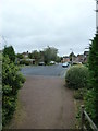
Looking from Mentmore Road through into Camberton Road
Image: © Basher Eyre
Taken: 8 Sep 2011
0.09 miles
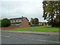
8
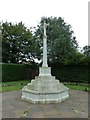
Linslade War Memorial in early September 2011
Image: © Basher Eyre
Taken: 8 Sep 2011
0.09 miles
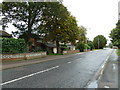
10
Junction of Ashburnham Road and Mentmore Road
Image: © Basher Eyre
Taken: 8 Sep 2011
0.10 miles