IMAGES TAKEN NEAR TO
Old Farm Close, LEIGHTON BUZZARD, LU7 0UF
Introduction
This page details the photographs taken nearby to Old Farm Close, LU7 0UF by members of the Geograph project.
The Geograph project started in 2005 with the aim of publishing, organising and preserving representative images for every square kilometre of Great Britain, Ireland and the Isle of Man.

There are currently over 7.5m images from over14,400 individuals and you can help contribute to the project by visiting https://www.geograph.org.uk
Image Map
Images are licensed for reuse under creativecommons.org/licenses/by-sa/2.0
Notes
- Clicking on the map will re-center to the selected point.
- The higher the marker number, the further away the image location is from the centre of the postcode.
Image Listing (16 Images Found)
Images are licensed for reuse under creativecommons.org/licenses/by-sa/2.0
Image
Details
Distance
1
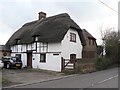
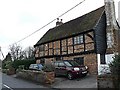
"King's Head", Horton
View from the main road through Horton looking South.
Image: © Chris Cole
Taken: 18 Feb 2006
0.03 miles
2
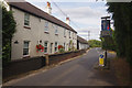
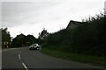
Horton
There is traffic calming here where the B488 passes through the hamlet of Horton. The road can be busy with a high proportion of heavy lorries.
Image: © Stephen McKay
Taken: 30 Aug 2018
0.03 miles
5
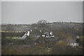
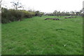
Lanthorn Cottage, Horton
Viewed from the main road through Horton, looking South
Image: © Chris Cole
Taken: 18 Feb 2006
0.14 miles

10

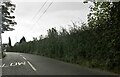
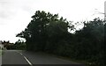
Railway Bridge
Carrying the Euston mainline.
Image: © Mr Biz
Taken: 30 Sep 2011
0.21 miles