IMAGES TAKEN NEAR TO
Moorlands Road, LEIGHTON BUZZARD, LU7 0RD
Introduction
This page details the photographs taken nearby to Moorlands Road, LU7 0RD by members of the Geograph project.
The Geograph project started in 2005 with the aim of publishing, organising and preserving representative images for every square kilometre of Great Britain, Ireland and the Isle of Man.

There are currently over 7.5m images from over14,400 individuals and you can help contribute to the project by visiting https://www.geograph.org.uk
Image Map
Images are licensed for reuse under creativecommons.org/licenses/by-sa/2.0
Notes
- Clicking on the map will re-center to the selected point.
- The higher the marker number, the further away the image location is from the centre of the postcode.
Image Listing (20 Images Found)
Images are licensed for reuse under creativecommons.org/licenses/by-sa/2.0
Image
Details
Distance
2
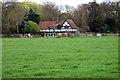
Black and white cattle in front of a black and white house
Image: © Philip Jeffrey
Taken: 29 Apr 2013
0.13 miles
8
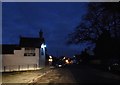
Stewkley Road, Wing
To the left out of shot is Wings Chinese restaurant, naturally.
Image: © David Howard
Taken: 4 Feb 2018
0.19 miles
9
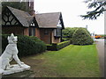
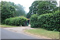
Leighton Road gate house
The Leighton Road gate house of Ascott House
Image: © Shaun Ferguson
Taken: 9 Apr 2012
0.24 miles
