IMAGES TAKEN NEAR TO
Wantage Crescent, LEIGHTON BUZZARD, LU7 0NH
Introduction
This page details the photographs taken nearby to Wantage Crescent, LU7 0NH by members of the Geograph project.
The Geograph project started in 2005 with the aim of publishing, organising and preserving representative images for every square kilometre of Great Britain, Ireland and the Isle of Man.

There are currently over 7.5m images from over14,400 individuals and you can help contribute to the project by visiting https://www.geograph.org.uk
Image Map
Images are licensed for reuse under creativecommons.org/licenses/by-sa/2.0
Notes
- Clicking on the map will re-center to the selected point.
- The higher the marker number, the further away the image location is from the centre of the postcode.
Image Listing (7 Images Found)
Images are licensed for reuse under creativecommons.org/licenses/by-sa/2.0
Image
Details
Distance
1

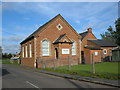
Wing Union Chapel
This little chapel is on the righthand side of the road to Burcott out of Wing.
Image: © Rob Farrow
Taken: 20 Dec 2006
0.03 miles
2
Wing Union Chapel
On the road from Wing to Burcott, this Chapel has its own website. http://www.wingchapel.org.uk/
Image: © Mr Biz
Taken: 23 Oct 2010
0.03 miles
3
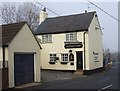
Sportsman's Arms, Wing
This pub is situated almost opposite Image
Image: © Rob Farrow
Taken: 20 Dec 2006
0.09 miles
4
Stewkley Road, Wing
To the left out of shot is Wings Chinese restaurant, naturally.
Image: © David Howard
Taken: 4 Feb 2018
0.15 miles
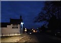
6
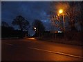
Stewkley Road at the junction of Wing High Street
Image: © David Howard
Taken: 4 Feb 2018
0.23 miles