IMAGES TAKEN NEAR TO
Cublington, LEIGHTON BUZZARD, LU7 0LS
Introduction
This page details the photographs taken nearby to LU7 0LS by members of the Geograph project.
The Geograph project started in 2005 with the aim of publishing, organising and preserving representative images for every square kilometre of Great Britain, Ireland and the Isle of Man.

There are currently over 7.5m images from over14,400 individuals and you can help contribute to the project by visiting https://www.geograph.org.uk
Image Map
Images are licensed for reuse under creativecommons.org/licenses/by-sa/2.0
Notes
- Clicking on the map will re-center to the selected point.
- The higher the marker number, the further away the image location is from the centre of the postcode.
Image Listing (9 Images Found)
Images are licensed for reuse under creativecommons.org/licenses/by-sa/2.0
Image
Details
Distance
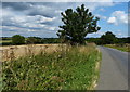
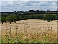
3
Road passing New Dairy Farm
Road passing entrance to New Dairy Farm
Image: © Shaun Ferguson
Taken: 12 Nov 2011
0.17 miles
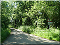
6
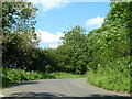
Sharp bend on Stewkley Road
The way from Cublington to Stewkley.
Image: © Robin Webster
Taken: 5 Jun 2014
0.22 miles
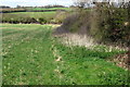
7
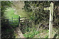
Footbridge over stream
Footbridge along stream from Kingsbridge picnic spot
Image: © Mike Wilkinson
Taken: 8 Oct 2006
0.24 miles
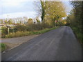
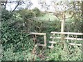
8
Road liable to flooding
The start of this lane which indeed was modestly flooded by a stream crossing.
Image: © Robin Webster
Taken: 5 Jun 2014
0.24 miles