IMAGES TAKEN NEAR TO
Lancaster Business Park, Cublington Road, LEIGHTON BUZZARD, LU7 0LA
Introduction
This page details the photographs taken nearby to Lancaster Business Park, Cublington Road, LU7 0LA by members of the Geograph project.
The Geograph project started in 2005 with the aim of publishing, organising and preserving representative images for every square kilometre of Great Britain, Ireland and the Isle of Man.

There are currently over 7.5m images from over14,400 individuals and you can help contribute to the project by visiting https://www.geograph.org.uk
Image Map
Images are licensed for reuse under creativecommons.org/licenses/by-sa/2.0
Notes
- Clicking on the map will re-center to the selected point.
- The higher the marker number, the further away the image location is from the centre of the postcode.
Image Listing (9 Images Found)
Images are licensed for reuse under creativecommons.org/licenses/by-sa/2.0
Image
Details
Distance
1
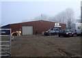
Business Unit, South Tinkers Hole
One of several business units situated near South Tinkers Hole Farm. This one belongs to Lotus Exhibitions, a design company.
Image: © Rob Farrow
Taken: 20 Dec 2006
0.07 miles
2
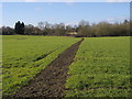
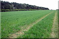
Outer Aylesbury Ring
Outer Aylesbury Ring path heads to South Tinkers Hole Farm
Image: © Shaun Ferguson
Taken: 6 Feb 2015
0.11 miles
3

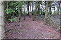
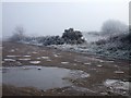
Trees at South Tinkers Hole
Hoar frost covered trees near to South Tinkers Hole Farm.
Image: © Rob Farrow
Taken: 20 Dec 2006
0.12 miles
6
Outer Aylesbury Ring
Outer Aylesbury Ring path heads past South Tinkers Hole Farm outbuildings
Image: © Shaun Ferguson
Taken: 6 Feb 2015
0.21 miles
7
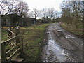
South Tinkers Hole Tracks
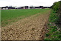
There are numerous criss-crossing tracks and lanes, mostly tarmacked (though here one that isn't tarmacked is seen leaving the main track that is). They are mostly straight and could well have had a military use in the war perhaps. To the right here is a field of crops, cabbages or kale I think.
(For Airfield info see Image])
Image: © Rob Farrow
Taken: 20 Dec 2006
0.23 miles
8
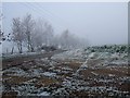
Frozen puddles, Cottesloe
These wide tracks at Cottesloe (which I think may have once been part of an airfield or something similar) are heavily rutted and pot-holed. The holes have filled with water and have now frozen solid with the heavy frost. This will of course make the damage to the tracks yet worse.
[Edit 3/4/08] The following information was sent in by Ant Basterfield :
"This WWII old aerodrome which opened in late 1941 went on to become an OTU unit, but did take part in the Cologne 1,000 plane raid. It stayed as an active R.A.F Station (mostly OTU) Wing until June 1945 and during its time saw many different aeroplanes Including the little known Aircraft the Martin Baker MB-3 which was fitted with an ejector seat! The aerodrome was disposed of finally in 1960. If you require more information please see the book, "Action Stations no 6", a book about all the military airfields of the cotswolds and central midlands By Michael JF Bowyer."
Image: © Rob Farrow
Taken: 20 Dec 2006
0.23 miles