IMAGES TAKEN NEAR TO
Wing Road, LEIGHTON BUZZARD, LU7 0FQ
Introduction
This page details the photographs taken nearby to Wing Road, LU7 0FQ by members of the Geograph project.
The Geograph project started in 2005 with the aim of publishing, organising and preserving representative images for every square kilometre of Great Britain, Ireland and the Isle of Man.

There are currently over 7.5m images from over14,400 individuals and you can help contribute to the project by visiting https://www.geograph.org.uk
Image Map
Images are licensed for reuse under creativecommons.org/licenses/by-sa/2.0
Notes
- Clicking on the map will re-center to the selected point.
- The higher the marker number, the further away the image location is from the centre of the postcode.
Image Listing (8 Images Found)
Images are licensed for reuse under creativecommons.org/licenses/by-sa/2.0
Image
Details
Distance
1
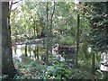
The pool at The Granary, Cublington
A property called The Granary is on Reads Lane in Cublington, this pool adjoins the lane. Reads Lane is a narrow back lane in the village which probably gets very little traffic, making this a particularly tranquil spot.
Image: © Rob Farrow
Taken: 7 Sep 2006
0.10 miles
2
The Biggs Pavilion, Orchard Ground, Cublington
A cricket ground and pavilion in Cublington. There's a small playground over the back of the pavilion.
Image: © Mr Biz
Taken: 22 May 2008
0.17 miles
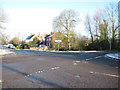
4
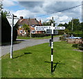
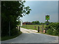
Signpost in the centre of Cublington
At the junction of Wing Road and Stewkley Road.
Image: © Mat Fascione
Taken: 16 Aug 2015
0.17 miles
5
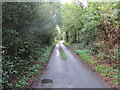
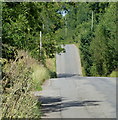
Tree-lined Reads Lane near to Cublington
Looking southward.
Image: © Peter Wood
Taken: 6 Oct 2019
0.18 miles
6
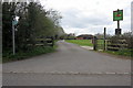
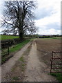
Public footpath by the cricket field
Image: © Philip Jeffrey
Taken: 29 Apr 2013
0.20 miles