IMAGES TAKEN NEAR TO
Bletchley Road, LEIGHTON BUZZARD, LU7 0ER
Introduction
This page details the photographs taken nearby to Bletchley Road, LU7 0ER by members of the Geograph project.
The Geograph project started in 2005 with the aim of publishing, organising and preserving representative images for every square kilometre of Great Britain, Ireland and the Isle of Man.

There are currently over 7.5m images from over14,400 individuals and you can help contribute to the project by visiting https://www.geograph.org.uk
Image Map
Images are licensed for reuse under creativecommons.org/licenses/by-sa/2.0
Notes
- Clicking on the map will re-center to the selected point.
- The higher the marker number, the further away the image location is from the centre of the postcode.
Image Listing (7 Images Found)
Images are licensed for reuse under creativecommons.org/licenses/by-sa/2.0
Image
Details
Distance
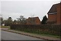
1
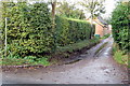
Footpath up the lane past Grange Farm to Drayton Parslow
Image: © Philip Jeffrey
Taken: 30 Oct 2012
0.02 miles
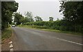
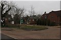
3
Stewkley Northend Crossroads
The crossroads at Stewkley Northend. The whole village is now known as Stewkley, and is also referred to as now on maps.
Image: © Mr Biz
Taken: 30 Jul 2006
0.14 miles
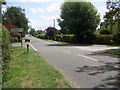
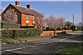
6
High Street North, Stewkley
Looking into Grubbs Close
Image: © David Howard
Taken: 28 Dec 2019
0.21 miles
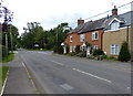
7
Bowles Farm North End, Stewkley
Picked out in the sunshine and surrounded by pink blossom, this is the Farmhouse for Bowles Farm.
Image: © Richard Thomas
Taken: 28 Feb 2007
0.21 miles