IMAGES TAKEN NEAR TO
Evans Yard, LEIGHTON BUZZARD, LU7 0EQ
Introduction
This page details the photographs taken nearby to Evans Yard, LU7 0EQ by members of the Geograph project.
The Geograph project started in 2005 with the aim of publishing, organising and preserving representative images for every square kilometre of Great Britain, Ireland and the Isle of Man.

There are currently over 7.5m images from over14,400 individuals and you can help contribute to the project by visiting https://www.geograph.org.uk
Image Map
Images are licensed for reuse under creativecommons.org/licenses/by-sa/2.0
Notes
- Clicking on the map will re-center to the selected point.
- The higher the marker number, the further away the image location is from the centre of the postcode.
Image Listing (45 Images Found)
Images are licensed for reuse under creativecommons.org/licenses/by-sa/2.0
Image
Details
Distance
2
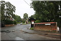
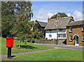
Heath and Reach
This is the centre of the village by the green
Image: © David Howard
Taken: 27 Jun 2020
0.02 miles
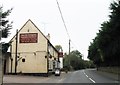
4
Heath Village Barn
This is for hire and looks like it's been converted into a village hall.
Image: © Des Blenkinsopp
Taken: 6 May 2013
0.04 miles
6
Heath Green
Heath Green in Heath and Reach with period cottages and a modern Post box!
Image: © Richard Thomas
Taken: 20 Aug 2006
0.05 miles
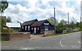
7
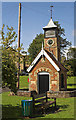
1873 Pump House and Clock Tower
The unusual building is located on Heath Green in Heath and Reach. 1873. It is a grade 2 listed structure listed as: One storey brick shed with gable end, the sides with cambered headed archways filled by iron railings. Gable ends. Tile roof. One gable end has plain door with cambered arch. Rising above the roof at the opposite end is a 2 stage square brick turrett with clock dial surmounted by louvred belfry. Pyramid roof and vane with cardinal points. Iron pumping machinery inside. A prominent feature of the village green.
Image: © Richard Thomas
Taken: 20 Aug 2006
0.05 miles
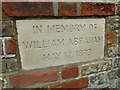
9
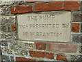
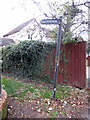
Inscription on the pump house
Obviously a practical as well as a religious man http://www.geograph.org.uk/photo/2594110
Image: © Basher Eyre
Taken: 6 Sep 2011
0.07 miles
10
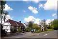
Heath and Reach
A view of Heath Green in the middle of the village, with the splendid combined pump and clock house, the trademark Bedfordshire village name board, the Wesleyan Church behind the trees in the background and some of the old houses.
My usually trusty Dictionary of Place Names has nothing to say about the unusual name Heath and Reach.
Elsewhere, I found a suggestion that it's as simple as one part of the parish being on sand, hence heath, and part being on a length, or reach, of the River Ouzel. However, the obvious frequently isn't correct when it comes to place names, so I'll leave it there.
Image: © Des Blenkinsopp
Taken: 6 May 2013
0.07 miles