IMAGES TAKEN NEAR TO
The Mead, LEIGHTON BUZZARD, LU7 0EG
Introduction
This page details the photographs taken nearby to The Mead, LU7 0EG by members of the Geograph project.
The Geograph project started in 2005 with the aim of publishing, organising and preserving representative images for every square kilometre of Great Britain, Ireland and the Isle of Man.

There are currently over 7.5m images from over14,400 individuals and you can help contribute to the project by visiting https://www.geograph.org.uk
Image Map
Images are licensed for reuse under creativecommons.org/licenses/by-sa/2.0
Notes
- Clicking on the map will re-center to the selected point.
- The higher the marker number, the further away the image location is from the centre of the postcode.
Image Listing (44 Images Found)
Images are licensed for reuse under creativecommons.org/licenses/by-sa/2.0
Image
Details
Distance
2
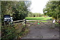
Entrance to the Millennium green space
Image: © Philip Jeffrey
Taken: 18 Oct 2012
0.05 miles
5

Cross Bucks Way toward the cricket ground
Image: © Philip Jeffrey
Taken: 18 Oct 2012
0.08 miles
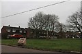
6
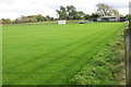
Soulbury Cricket ground and pavilion
Image: © Philip Jeffrey
Taken: 18 Oct 2012
0.09 miles
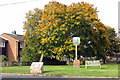
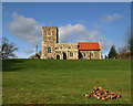
7
All Saints Church, Soulbury
Located fairly centrally in Soulbury, seems strange to see sheep grazing in somewhere so "busy".
Image: © Mr Biz
Taken: 20 May 2008
0.09 miles
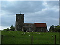
8
All Saints Church Soulbury
The Parish Church of Soulbury, All Saints, stands in a commanding position over the village of Soulbury.
Image: © Richard Thomas
Taken: 28 Feb 2007
0.09 miles
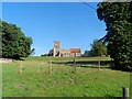
10
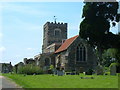
All Saints Church Soulbury
A view of the All Saints church from the entrance gate just off the main road.
Image: © Mr Biz
Taken: 8 Jun 2008
0.10 miles