IMAGES TAKEN NEAR TO
Bragenham, LEIGHTON BUZZARD, LU7 0EF
Introduction
This page details the photographs taken nearby to LU7 0EF by members of the Geograph project.
The Geograph project started in 2005 with the aim of publishing, organising and preserving representative images for every square kilometre of Great Britain, Ireland and the Isle of Man.

There are currently over 7.5m images from over14,400 individuals and you can help contribute to the project by visiting https://www.geograph.org.uk
Image Map
Images are licensed for reuse under creativecommons.org/licenses/by-sa/2.0
Notes
- Clicking on the map will re-center to the selected point.
- The higher the marker number, the further away the image location is from the centre of the postcode.
Image Listing (4 Images Found)
Images are licensed for reuse under creativecommons.org/licenses/by-sa/2.0
Image
Details
Distance
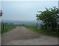
1
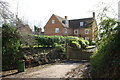
Entrance to 'Hawkstone' from Bragenham Lane
Image: © Roger Templeman
Taken: 2 Mar 2017
0.01 miles
3
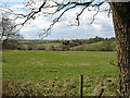
Kiln Farm
View from the Three Locks / Great Brickhill circular walk. Kiln Farm nestles in the valley, whilst the village of Bragenham is visible amongst the trees behind.
Image: © Martin Addison
Taken: 17 Apr 2006
0.19 miles
4
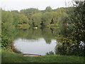
Fishing pond between Alders Farm and Oak Wood
Image: © Peter S
Taken: 25 Oct 2015
0.23 miles