IMAGES TAKEN NEAR TO
Stockgrove, LEIGHTON BUZZARD, LU7 0BB
Introduction
This page details the photographs taken nearby to LU7 0BB by members of the Geograph project.
The Geograph project started in 2005 with the aim of publishing, organising and preserving representative images for every square kilometre of Great Britain, Ireland and the Isle of Man.

There are currently over 7.5m images from over14,400 individuals and you can help contribute to the project by visiting https://www.geograph.org.uk
Image Map
Images are licensed for reuse under creativecommons.org/licenses/by-sa/2.0
Notes
- Clicking on the map will re-center to the selected point.
- The higher the marker number, the further away the image location is from the centre of the postcode.
Image Listing (11 Images Found)
Images are licensed for reuse under creativecommons.org/licenses/by-sa/2.0
Image
Details
Distance
1
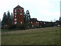
Stockgrove Park House
The http://www.shindles.co.uk/stockgrove/index.htm gives an historical overview of the area including plans of the clock tower and stables which appear to have been built in the early 1900's.
Image: © Michael Trolove
Taken: 22 Jan 2012
0.07 miles
2
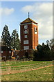
The tower at Stockgrove Park House
The elaborate vane on top of the building is an Ordnance Survey intersected station trig point
Image: © Roger Templeman
Taken: 2 Mar 2017
0.07 miles
3
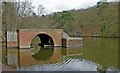
Stockgrove Country Park
The (artificial) lake was excavated in the 1920s and the boathouse was built soon afterwards. The boathouse used to have a room above with a thatched roof - but it burned down in the 1960s. Part of the drawbridge mechanism remains on the left hand side.
Image: © Peter Roberts
Taken: 10 Apr 2005
0.09 miles
4
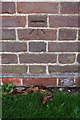
Benchmark on #1 North Lodge
Ordnance Survey cut mark benchmark described on the Bench Mark Database at http://www.bench-marks.org.uk/bm82639
Image: © Roger Templeman
Taken: 2 Mar 2017
0.12 miles
5

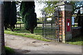
#1 North Lodge at entrance to Stockgrove Park
There is an OS benchmark Image at the middle of the lodge
Image: © Roger Templeman
Taken: 2 Mar 2017
0.12 miles
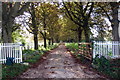
6
Greensand Ridge Walk and Georgian Postbox
Image: © Philip Jeffrey
Taken: 16 Oct 2012
0.13 miles
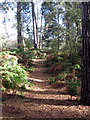
7

Greensand Ridge Walk comes out of the wood
Image: © Philip Jeffrey
Taken: 16 Oct 2012
0.14 miles
8
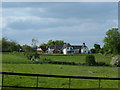
View of Cherry Orchard Farm
Located off the Heath Road, just outside Great Brickhill.
Image: © Mr Biz
Taken: 20 May 2008
0.19 miles