IMAGES TAKEN NEAR TO
Fossett Grove, DUNSTABLE, LU6 3FJ
Introduction
This page details the photographs taken nearby to Fossett Grove, LU6 3FJ by members of the Geograph project.
The Geograph project started in 2005 with the aim of publishing, organising and preserving representative images for every square kilometre of Great Britain, Ireland and the Isle of Man.

There are currently over 7.5m images from over14,400 individuals and you can help contribute to the project by visiting https://www.geograph.org.uk
Image Map
Images are licensed for reuse under creativecommons.org/licenses/by-sa/2.0
Notes
- Clicking on the map will re-center to the selected point.
- The higher the marker number, the further away the image location is from the centre of the postcode.
Image Listing (14 Images Found)
Images are licensed for reuse under creativecommons.org/licenses/by-sa/2.0
Image
Details
Distance
1
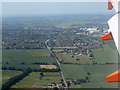
Watling Street - Roman Road
From above Turnpike Farm, looking northwestwards beyond Dunstable.
Image: © M J Richardson
Taken: 11 Jul 2013
0.09 miles
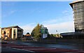
2
Holiday Inn Express Dunstable, London Road
Image: © Bryn Holmes
Taken: 1 Jul 2017
0.10 miles
3

Holiday Inn Express Dunstable, London Road
Image: © Bryn Holmes
Taken: 30 Jun 2017
0.11 miles
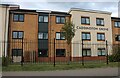
4
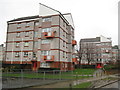
Dunstable: Morcom Road
These are two of the seven blocks of flats on Morcom Road on the Downside Estate, photographed on a very wet day.
Image: © Nigel Cox
Taken: 11 Jan 2008
0.11 miles

6

Holiday Inn Express, Dunstable
I'm not sure why it's called express, maybe they throw you out earlier. Here's a previous visit. https://www.geograph.org.uk/photo/6226131
Image: © David Howard
Taken: 6 Nov 2022
0.13 miles
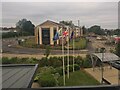
7
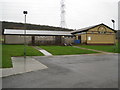
Dunstable: Downside Community Centre
A quick glance at a recent online programme of events showed that a wide range of interests are catered for at the centre, ranging from baton twirling to a model railway club, via ninjitsi. It is located at the south-eastern end of Suffolk Road on the Downside Estate. The building at the right is relatively new and does not show on the Ordnance Survey 1:10,000 scale mapping.
Image: © Nigel Cox
Taken: 11 Jan 2008
0.13 miles
8
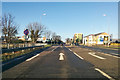
A5183 London Road, Dunstable
Watling Street, a Roman Road, formerly the A5.
Image: © Robin Webster
Taken: 7 Jan 2018
0.13 miles