IMAGES TAKEN NEAR TO
Harling Road, DUNSTABLE, LU6 2LA
Introduction
This page details the photographs taken nearby to Harling Road, LU6 2LA by members of the Geograph project.
The Geograph project started in 2005 with the aim of publishing, organising and preserving representative images for every square kilometre of Great Britain, Ireland and the Isle of Man.

There are currently over 7.5m images from over14,400 individuals and you can help contribute to the project by visiting https://www.geograph.org.uk
Image Map
Images are licensed for reuse under creativecommons.org/licenses/by-sa/2.0
Notes
- Clicking on the map will re-center to the selected point.
- The higher the marker number, the further away the image location is from the centre of the postcode.
Image Listing (13 Images Found)
Images are licensed for reuse under creativecommons.org/licenses/by-sa/2.0
Image
Details
Distance
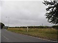
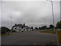
2
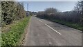
Harling Road
Harling Road approaching the roundabout with the B489 and B4506
Image: © Shaun Ferguson
Taken: 30 Mar 2021
0.09 miles
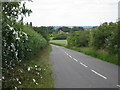
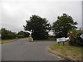
3
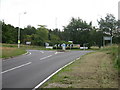
Roundabout from Harling Road
At junction with Tring Road left, Dangall Road ahead, and Icknield Way right.
Image: © Oast House Archive
Taken: 1 Jul 2011
0.09 miles
4
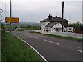
B489/B4540 Junction nr. Whipsnade
The slightly surreal AA sign does not, of course, lead the motorist to the plains of East Africa, but instead to Whipsnade Zoo. The building on the right is marked on older OS maps as the Plough Inn, but is now an indian restaurant.
Image: © Stephen McKay
Taken: 30 Apr 2006
0.10 miles
5
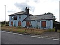
Former 'New York Diner', Icknield Way
Image: © Roger Cornfoot
Taken: 22 Jun 2019
0.10 miles
6
Roundabout on Dagnall Road, Eaton Bray
The little pub is now the New York Diner
Image: © David Howard
Taken: 19 Jul 2017
0.11 miles
7
Roundabout on Dagnall Road, Eaton Bray
Image: © David Howard
Taken: 19 Jul 2017
0.11 miles