IMAGES TAKEN NEAR TO
Bottom Drive, DUNSTABLE, LU6 2JS
Introduction
This page details the photographs taken nearby to Bottom Drive, LU6 2JS by members of the Geograph project.
The Geograph project started in 2005 with the aim of publishing, organising and preserving representative images for every square kilometre of Great Britain, Ireland and the Isle of Man.

There are currently over 7.5m images from over14,400 individuals and you can help contribute to the project by visiting https://www.geograph.org.uk
Image Map
Images are licensed for reuse under creativecommons.org/licenses/by-sa/2.0
Notes
- Clicking on the map will re-center to the selected point.
- The higher the marker number, the further away the image location is from the centre of the postcode.
Image Listing (14 Images Found)
Images are licensed for reuse under creativecommons.org/licenses/by-sa/2.0
Image
Details
Distance
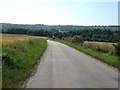
4
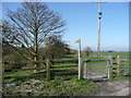
Bridleway to Eaton Bray
Gate has a long handle for horse-riders. View south-east from Well Head Road.
Image: © Jonathan Billinger
Taken: 9 Apr 2008
0.15 miles
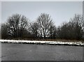
5
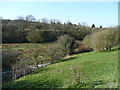
A natural bowl
At the base of the Chiltern scarp is this natural bowl from where springs arise.
Image: © Jonathan Billinger
Taken: 9 Apr 2008
0.16 miles
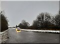
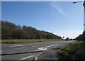
8
Wellhead Road
This road out of Totternhoe heads southeast through unfenced fields. Ahead the steep slope of Dunstable Downs can be seen rising up 70m or so. (from c.150m to c.220m)
Image: © Rob Farrow
Taken: 29 Jun 2006
0.19 miles
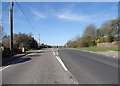
10
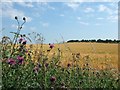
Barley and Knapweed flowers
I originally thought that these were purple cornflowers. (See Image)
There are large open fields either side of the unfenced Wellhead Road out of Totternhoe.
Image: © Rob Farrow
Taken: 29 Jun 2006
0.22 miles