IMAGES TAKEN NEAR TO
Harling Road, DUNSTABLE, LU6 2JB
Introduction
This page details the photographs taken nearby to Harling Road, LU6 2JB by members of the Geograph project.
The Geograph project started in 2005 with the aim of publishing, organising and preserving representative images for every square kilometre of Great Britain, Ireland and the Isle of Man.

There are currently over 7.5m images from over14,400 individuals and you can help contribute to the project by visiting https://www.geograph.org.uk
Image Map
Images are licensed for reuse under creativecommons.org/licenses/by-sa/2.0
Notes
- Clicking on the map will re-center to the selected point.
- The higher the marker number, the further away the image location is from the centre of the postcode.
Image Listing (11 Images Found)
Images are licensed for reuse under creativecommons.org/licenses/by-sa/2.0
Image
Details
Distance
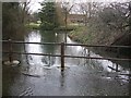
2
Stream at Edlesborough - View northwards
This is quite a substantial watercourse for this area. The underlying chalk tends to allow most water to drain to deep subterranean aquifers, making decent-sized streams and rivers quite a rarity. This one is particularly wide here - considerably wider indeed than the River Ouzel into which it eventually flows - but I think this width may be as a result of human activity as this stream once supplied several mills including Edlesborough Mills (to the south) and Bellows Mill - a little way ahead of this view.
For a view of this stream upstream see Image], and it crossing the road as a ford in Image] & Image]
Image: © Rob Farrow
Taken: 22 Feb 2009
0.03 miles
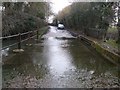
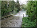
3
Ford near Edlesborough Mills - View eastwards
This ford is on a back lane to the southeast of the village of Edlesborough. The stream is flowing roughly northwards at this point, i.e. from right to left as we look at this. The Mills mentioned in the title are long disused, and have I think been converted to housing. This earlier photo for this square Image] is taken from much the same place and shows a car splashing through the ford.
For views from the other compass points see Image] Image] & Image]
Image: © Rob Farrow
Taken: 22 Feb 2009
0.03 miles
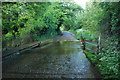
4
Ford near Edlesborough Mills - View westwards
Looking in precisely the opposite direction to Image] this substantial stream can be seen flowing from left to right across the road. This stream eventually joins the River Ouzel - though if it continues at this breadth it must be the bigger watercourse when they meet. See also Image] & Image] for views up and down the stream taken from the middle of the ford.
Image: © Rob Farrow
Taken: 22 Feb 2009
0.03 miles
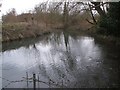
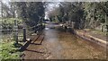
5
Stream at Edlesborough - View southwards
This is the stream which can be seen crossing the road as a ford in Image] & Image The view southwards is upstream and is therefore looking in the direction of the former Edlesborough Mills, which (I think) can be seen ahead - now converted to housing. This stream obviously provided the power for those mills, though next door is a disused windmill for alternative energy perhaps. The ducks seen ahead - one white and one mallard drake - were just gliding over the road as I approached in the car. For the view downstream see Image]
Image: © Rob Farrow
Taken: 22 Feb 2009
0.03 miles
6
Eaton Bray Ford
This ford is found at Eaton Bray near Edlesborough on the Bedfordshire border with Buckinghamshire.
I am advised by the Parish Clerk at Eaton Bray Parish Council that the boundary line was amended in 1985 by the Government Boundary Commission for England and the ford lies in Bedfordshire.
Image: © John Walton
Taken: 2 Jun 2013
0.03 miles
7
Ford on the road into Edlesborough
Ford part of the River Ouzel on the road into Edlesborough
Image: © Shaun Ferguson
Taken: 30 Mar 2021
0.04 miles
8

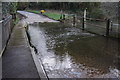
Ford on the lane
With a raised walkway on the right.
Image: © Jeremy Bolwell
Taken: 16 Jan 2022
0.05 miles
9

Water channel beside the road
With interesting wooden hurdles fitted in the stream bed to, reduce erosion or flow, I assume.
Image: © Jeremy Bolwell
Taken: 16 Jan 2022
0.06 miles
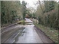
10
Ford at Edlesborough
A car splashes through this ford on a minor road just outside Edlesborough village. The stream forms the boundary between Buckinghamshire (this side) and Bedfordshire.
Image: © Stephen McKay
Taken: 30 Apr 2006
0.09 miles