IMAGES TAKEN NEAR TO
Chapel Lane, DUNSTABLE, LU6 2HF
Introduction
This page details the photographs taken nearby to Chapel Lane, LU6 2HF by members of the Geograph project.
The Geograph project started in 2005 with the aim of publishing, organising and preserving representative images for every square kilometre of Great Britain, Ireland and the Isle of Man.

There are currently over 7.5m images from over14,400 individuals and you can help contribute to the project by visiting https://www.geograph.org.uk
Image Map
Images are licensed for reuse under creativecommons.org/licenses/by-sa/2.0
Notes
- Clicking on the map will re-center to the selected point.
- The higher the marker number, the further away the image location is from the centre of the postcode.
Image Listing (6 Images Found)
Images are licensed for reuse under creativecommons.org/licenses/by-sa/2.0
Image
Details
Distance
1
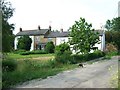
Terraced cottages, Northall - with cat
These cottages are at the end of the lane with Image on it. They run along part of the Two Ridges Link.
Image: © Rob Farrow
Taken: 7 Jun 2006
0.01 miles
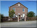
2
Northall Baptist Church
... in case you hadn't noticed ! Some places can be tricky to identify, while others ...
This is down a little lane which strikes off to the southwest from the busy A4146 through the main part of Northall.
Image: © Rob Farrow
Taken: 7 Jun 2006
0.05 miles
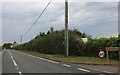
4
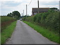
Chapel Lane
Dead end lane to Kircutt.
Image: © Oast House Archive
Taken: 1 Jul 2011
0.10 miles
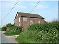
5
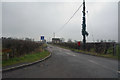
Northall : Chapel Lane
A small lane heading off from Leighton Road.
Image: © Lewis Clarke
Taken: 24 Mar 2018
0.17 miles