IMAGES TAKEN NEAR TO
Lords Mead, DUNSTABLE, LU6 2FB
Introduction
This page details the photographs taken nearby to Lords Mead, LU6 2FB by members of the Geograph project.
The Geograph project started in 2005 with the aim of publishing, organising and preserving representative images for every square kilometre of Great Britain, Ireland and the Isle of Man.

There are currently over 7.5m images from over14,400 individuals and you can help contribute to the project by visiting https://www.geograph.org.uk
Image Map
Images are licensed for reuse under creativecommons.org/licenses/by-sa/2.0
Notes
- Clicking on the map will re-center to the selected point.
- The higher the marker number, the further away the image location is from the centre of the postcode.
Image Listing (46 Images Found)
Images are licensed for reuse under creativecommons.org/licenses/by-sa/2.0
Image
Details
Distance
2

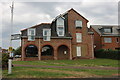
Moat Farm, Eaton Bray
Clearly a very old building with some more recent additions. The entrance is from the High Street and the farm buildings are now completely surrounded by more recent housing.
The name of the farm may be a reference to the moat that surrounded the castle in Eitone (as the village used to be known) - though that moat still exists on Park Farm, which is built on the site of the castle, to the Northwest of the village. It is possible that this was once a moated manor, but I have been unable to find any reference to it as such.
Image: © Martin Addison
Taken: 27 May 2009
0.03 miles
3
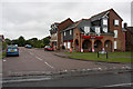
Castles estate agents on High Street, Eaton Bray
Image: © David Howard
Taken: 10 Sep 2023
0.04 miles
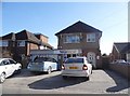
4
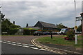
Wallace Drive and Threshers
Threshers occupies a large part of the ground floor of this shops and housing development on the corner of High Street and Wallace Drive.
Wallace Drive takes its name from the Wallace family who were major landowners in the area. The estate it leads into was the site of Wallace Nurseries and some of the streets within the estate are names after plant species that they cultivated. More information about Eaton Bray is available from the village website at http://www.eatonbray.com/
Image: © Martin Addison
Taken: 27 May 2009
0.05 miles
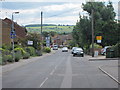
5
Wallace Drive, Eaton Bray
From the High Street
Image: © David Howard
Taken: 10 Sep 2023
0.06 miles
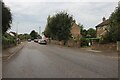
6

High Street, Eaton Bray
Looking through the village towards the Dunstable Downs.
Image: © Martin Addison
Taken: 27 May 2009
0.07 miles
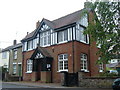
7
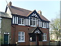
The Coffee Tavern, Eaton Bray
Located at 18 High Street LU6 2DP, this building dates from the late 19th Century and was opened in April 1901 for the men of the village to meet instead of being in the numerous local public houses that existed at the time. The upstairs consisted of a billiard table and comfortable chairs, with a coke-burning stove for heating. Downstairs provided reading rooms, with coffee available over a stable door in the kitchen. In the late 1990s, the building was refurbished by Eaton Bray Parish Council. Today, it is used as a meeting place for various groups including the Parish Council and the Youth Group. It is also available for hire, with the main hall suitable for approximately 50 people with kitchen facilities, and two smaller rooms available for say committee meetings.
Image: © David Hillas
Taken: 29 Mar 2011
0.10 miles