IMAGES TAKEN NEAR TO
Drovers Way, DUNSTABLE, LU6 1AP
Introduction
This page details the photographs taken nearby to Drovers Way, LU6 1AP by members of the Geograph project.
The Geograph project started in 2005 with the aim of publishing, organising and preserving representative images for every square kilometre of Great Britain, Ireland and the Isle of Man.

There are currently over 7.5m images from over14,400 individuals and you can help contribute to the project by visiting https://www.geograph.org.uk
Image Map
Images are licensed for reuse under creativecommons.org/licenses/by-sa/2.0
Notes
- Clicking on the map will re-center to the selected point.
- The higher the marker number, the further away the image location is from the centre of the postcode.
Image Listing (10 Images Found)
Images are licensed for reuse under creativecommons.org/licenses/by-sa/2.0
Image
Details
Distance
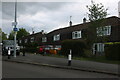
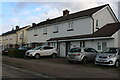
1
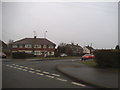
Pascombe Road at the junction of Drovers Way
Image: © David Howard
Taken: 11 Feb 2017
0.06 miles
4
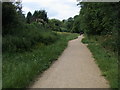
Chiltern Way
Chiltern Way on paved Green Lane
Image: © Shaun Ferguson
Taken: 22 Jun 2009
0.12 miles
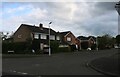
6
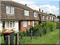
Houses on Brewers Hill Road, Dunstable
Image: © M J Richardson
Taken: 19 Jun 2011
0.17 miles
7
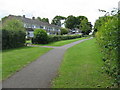
Saxon Close, Dunstable
Path through to the houses on Saxon and other closes from Brewers Hill Road.
Image: © M J Richardson
Taken: 19 Jun 2011
0.17 miles
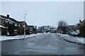
8
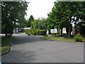
Weatherfield Community Special School
At the end of Brewers Hill Road on the western outskirts of Dunstable.
Image: © M J Richardson
Taken: 19 Jun 2011
0.19 miles
10
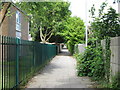
Alley by Weatherfield School
Leading through to houses on Saxon and Greenfield Closes.
Image: © M J Richardson
Taken: 19 Jun 2011
0.23 miles