IMAGES TAKEN NEAR TO
Luton Road, LUTON, LU4 9UJ
Introduction
This page details the photographs taken nearby to Luton Road, LU4 9UJ by members of the Geograph project.
The Geograph project started in 2005 with the aim of publishing, organising and preserving representative images for every square kilometre of Great Britain, Ireland and the Isle of Man.

There are currently over 7.5m images from over14,400 individuals and you can help contribute to the project by visiting https://www.geograph.org.uk
Image Map
Images are licensed for reuse under creativecommons.org/licenses/by-sa/2.0
Notes
- Clicking on the map will re-center to the selected point.
- The higher the marker number, the further away the image location is from the centre of the postcode.
Image Listing (13 Images Found)
Images are licensed for reuse under creativecommons.org/licenses/by-sa/2.0
Image
Details
Distance
2
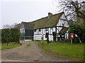
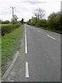
Chalton village hall
On Water End Lane.
Image: © Robin Webster
Taken: 13 Mar 2016
0.06 miles
7
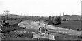
M1 Motorway under construction
Northward from bridge of B579 near Chalton, during early stages of construction - all very exciting at the time, although this was a Sunday. Note Sundon cement plant over to right; cf. my Image
Image: © Ben Brooksbank
Taken: 18 May 1958
0.20 miles
9
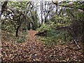
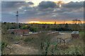
Footpath through the woods to the Icknield Way
Image: © Philip Jeffrey
Taken: 21 Nov 2021
0.21 miles
10
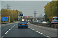
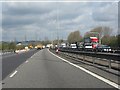
Central Bedfordshire : M1 Motorway
The M1 Motorway between Junction 11a and Junction 12 (Toddington).
Image: © Lewis Clarke
Taken: 5 Oct 2018
0.21 miles