IMAGES TAKEN NEAR TO
Laporte Way, LUTON, LU4 8RJ
Introduction
This page details the photographs taken nearby to Laporte Way, LU4 8RJ by members of the Geograph project.
The Geograph project started in 2005 with the aim of publishing, organising and preserving representative images for every square kilometre of Great Britain, Ireland and the Isle of Man.

There are currently over 7.5m images from over14,400 individuals and you can help contribute to the project by visiting https://www.geograph.org.uk
Image Map
Images are licensed for reuse under creativecommons.org/licenses/by-sa/2.0
Notes
- Clicking on the map will re-center to the selected point.
- The higher the marker number, the further away the image location is from the centre of the postcode.
Image Listing (11 Images Found)
Images are licensed for reuse under creativecommons.org/licenses/by-sa/2.0
Image
Details
Distance
1
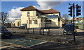
Former pub converted to a mosque, Kingsway, Luton
So a local man told me. Google Streetview shows that in 2009 this was the Kingsway Arms. In 2012 the conversion of the closed pub began. There is an extensive single-storey building on the north side, perhaps the former function room which (speculating) is now the place of worship. The part shown in the photograph may be the community centre. The view is across Connaught Road.
Image: © Robin Stott
Taken: 24 Feb 2017
0.09 miles
2
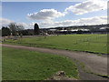
Kingsway Recreation Ground, west Luton
I remember as a child, in the late 1940s perhaps, seeing football being played on the Rec. Photographed from near the Dunstable Road entrance. Winsdon Hill on the skyline.
Image: © Robin Stott
Taken: 24 Feb 2017
0.12 miles
3
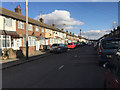
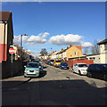
East on Connaught Road, Luton
When I was a small boy my mother walked us down here to visit a friend of hers. There was a Laporte chemical works off to the right somewhere, now an industrial estate I think. There was a smell in the air. Everything in the street was stained orange.
Image: © Robin Stott
Taken: 24 Feb 2017
0.17 miles
4
Dunstable Road entrance to Kingsway Recreation Ground, west Luton
Laid out probably in the late 1930s. There are steps down to a level area with a playground and a football pitch.
Image: © Robin Stott
Taken: 24 Feb 2017
0.18 miles
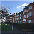
5
Dunstable Court flats, Dunstable Road, Luton
These flats first appear on an OS map of 1938 and were my first home for three or four years from 1944. To the south was a recreation ground, 'The Rec', and the Laporte chemical works. We moved to a corner house and pharmacy at No 453 before moving to Torquay in 1953, soon after the Coronation. Today the very busy A505 Dunstable Road connects to the M1 at Junction 11, about 1·5 km to the west.
Image: © Robin Stott
Taken: 24 Feb 2017
0.20 miles
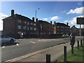
6
Dunstable Court flats, Dunstable Road, Luton
Dunstable Court consisted of three blocks of six flats each. No 13 is omitted. They first appeared on an OS map of 1938 and one of them was my first home from 1944. At the back a level recreation ground, the Rec, had been bulldozed by the Corporation out of a shallow valley-side.
Image: © Robin Stott
Taken: 24 Feb 2017
0.20 miles
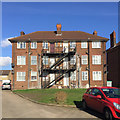
7
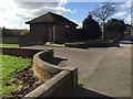
Rear of Dunstable Court flats, Dunstable Road, Luton
Dunstable Court consisted of three blocks of six flats each. No 13 is omitted. They first appeared on an OS map of 1938 and one of them was my first home from 1944. At the back, out of shot right, a level recreation ground, the Rec, had been bulldozed by the Corporation out of a shallow valley-side.
Image: © Robin Stott
Taken: 24 Feb 2017
0.20 miles
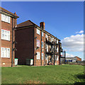
8
Rear of Nos 14-19 Dunstable Court, Dunstable Road, Luton
Dunstable Court consisted of three blocks of six flats each. No 13 is omitted. They first appeared on an OS map of 1938 and one of them was my first home from 1944. The view was across a recreation ground to the steaming, smoking Laporte chemical works in the valley. Everything in nearby streets was stained orange.
Image: © Robin Stott
Taken: 24 Feb 2017
0.21 miles
9
North on Chandos Road, Luton
The view is across Connaught Road.
Image: © Robin Stott
Taken: 24 Feb 2017
0.22 miles
10
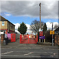
Dunstable Road entrance to Maidenhall Primary School, west Luton
I was a pupil here briefly in the early 1950s. Schools didn't have slogans then; now it's 'Believe Achieve Inspire'.
Image: © Robin Stott
Taken: 24 Feb 2017
0.22 miles