IMAGES TAKEN NEAR TO
Ash Road, LUTON, LU4 8AG
Introduction
This page details the photographs taken nearby to Ash Road, LU4 8AG by members of the Geograph project.
The Geograph project started in 2005 with the aim of publishing, organising and preserving representative images for every square kilometre of Great Britain, Ireland and the Isle of Man.

There are currently over 7.5m images from over14,400 individuals and you can help contribute to the project by visiting https://www.geograph.org.uk
Image Map
Images are licensed for reuse under creativecommons.org/licenses/by-sa/2.0
Notes
- Clicking on the map will re-center to the selected point.
- The higher the marker number, the further away the image location is from the centre of the postcode.
Image Listing (35 Images Found)
Images are licensed for reuse under creativecommons.org/licenses/by-sa/2.0
Image
Details
Distance
1
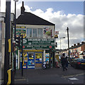
Corner shop, Dunstable Road, Bury Park, Luton
At the corner with Ash Road, right. The frontage is crowded with signs such as Srilankan Tamil Shop, Asian Food Store, Johal Food Store, Off Licence, Western Union, Moneygram, Cash Machine, Pay Point, Sea Food, Vegetables & Groceries. Bury Park is a bustling, mainly Pakistani, business and shopping area northwest of the town centre.
Image: © Robin Stott
Taken: 24 Feb 2017
0.06 miles
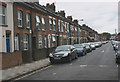
3
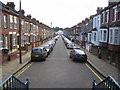
Luton: Beech Road
Viewed looking from the end of Beech Road back towards Dunstable Road, the blue railings are on a flight of steps leading up to an entrance to Luton Town's football ground. The Ordnance Survey mapping from 1888 shows this area to be open agricultural land around Bury Farm without a street in sight!
Image: © Nigel Cox
Taken: 25 Jun 2006
0.07 miles
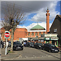
4
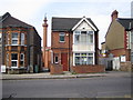
Luton: Jamia Masjid Ghousia Mosque
The mosque in Westbourne Road viewed between the houses on Leagrave Road.
Image: © Nigel Cox
Taken: 25 Jun 2006
0.08 miles
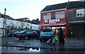
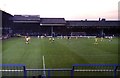
6

Executive boxes at Kenilworth Road
Kenilworth Road is the home of Luton Town.
Image: © Steve Daniels
Taken: 1 Mar 2017
0.10 miles
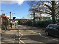
7
Mosque, Westbourne Road, Bury Park, Luton
It occurred to me that the people had attended Friday prayers.
Image: © Robin Stott
Taken: 24 Feb 2017
0.10 miles
8
Beech Hill on Dunstable Road, Luton
One beech tree is on the right behind the high fence to a sprawling primary school. The view is towards Bury Park from halfway down this long hill.
Image: © Robin Stott
Taken: 24 Feb 2017
0.10 miles
9

The Oak Road End at Kenilworth Road
Kenilworth Road is the home of Luton Town F.C.
Image: © Steve Daniels
Taken: 4 May 2019
0.10 miles
10
The Oak Road Stand at Kenilworth Road
Image: © Steve Daniels
Taken: 2 Sep 1980
0.10 miles