IMAGES TAKEN NEAR TO
Bishopscote Road, LUTON, LU3 1PE
Introduction
This page details the photographs taken nearby to Bishopscote Road, LU3 1PE by members of the Geograph project.
The Geograph project started in 2005 with the aim of publishing, organising and preserving representative images for every square kilometre of Great Britain, Ireland and the Isle of Man.

There are currently over 7.5m images from over14,400 individuals and you can help contribute to the project by visiting https://www.geograph.org.uk
Image Map
Images are licensed for reuse under creativecommons.org/licenses/by-sa/2.0
Notes
- Clicking on the map will re-center to the selected point.
- The higher the marker number, the further away the image location is from the centre of the postcode.
Image Listing (3 Images Found)
Images are licensed for reuse under creativecommons.org/licenses/by-sa/2.0
Image
Details
Distance
1
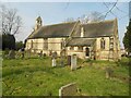
Luton: The Parish Church of Holy Trinity, Biscot
The Church was built in the Early English Gothic Revival Style between 1867 and 1868, to the designs of the architect T Nicholson of Hereford. It is constructed of yellow brick with red brick banding and red sandstone dressings, with a Welsh slated roof covering and coped gables.
It is a Grade II Listed Building.
Image: © Nigel Cox
Taken: 12 Mar 2016
0.13 miles
2
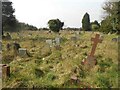
Luton: Graveyard of Holy Trinity Church, Biscot
The graveyard occupies a large area to the south of the Church.
The 1880 large scale Ordnance Survey map shows the church in the hamlet of "Biscott", in complete isolation from Luton.
Image: © Nigel Cox
Taken: 12 Mar 2016
0.13 miles
3
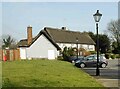
Luton: The Moat House, Biscot
The Moat House is a Grade II Listed Building, having as its origins a late 14th Century manor house. It was extensively modernized in the late 1960s. At the time of submission of this image it was closed due to Covid-19 restrictions, but was previously in use as a Stonehouse pizza and carvery restaurant.
Image: © Nigel Cox
Taken: 12 Mar 2016
0.22 miles