IMAGES TAKEN NEAR TO
Graham Gardens, LUTON, LU3 1NF
Introduction
This page details the photographs taken nearby to Graham Gardens, LU3 1NF by members of the Geograph project.
The Geograph project started in 2005 with the aim of publishing, organising and preserving representative images for every square kilometre of Great Britain, Ireland and the Isle of Man.

There are currently over 7.5m images from over14,400 individuals and you can help contribute to the project by visiting https://www.geograph.org.uk
Image Map
Images are licensed for reuse under creativecommons.org/licenses/by-sa/2.0
Notes
- Clicking on the map will re-center to the selected point.
- The higher the marker number, the further away the image location is from the centre of the postcode.
Image Listing (7 Images Found)
Images are licensed for reuse under creativecommons.org/licenses/by-sa/2.0
Image
Details
Distance
5
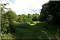
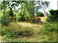
Upper Lea Valley walk 1
Despite being a small sliver of open land, hemmed in between Luton's suburban development, this walk has a feel of the countryside.
Image: © Robert Eva
Taken: 16 Jun 2017
0.24 miles
6
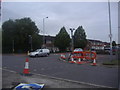
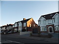
Austin Road at the junction of New Bedford Road
Image: © David Howard
Taken: 17 Aug 2011
0.24 miles
7
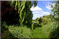
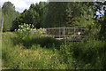
Path by the River Lea
This path leads to an area of open ground by the River Lea with allotments to the north and housing to the south.
Image: © Robert Eva
Taken: 16 Jun 2017
0.25 miles