IMAGES TAKEN NEAR TO
Althorp Road, LUTON, LU3 1JX
Introduction
This page details the photographs taken nearby to Althorp Road, LU3 1JX by members of the Geograph project.
The Geograph project started in 2005 with the aim of publishing, organising and preserving representative images for every square kilometre of Great Britain, Ireland and the Isle of Man.

There are currently over 7.5m images from over14,400 individuals and you can help contribute to the project by visiting https://www.geograph.org.uk
Image Map
Images are licensed for reuse under creativecommons.org/licenses/by-sa/2.0
Notes
- Clicking on the map will re-center to the selected point.
- The higher the marker number, the further away the image location is from the centre of the postcode.
Image Listing (10 Images Found)
Images are licensed for reuse under creativecommons.org/licenses/by-sa/2.0
Image
Details
Distance
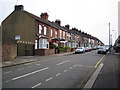
1
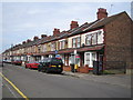
Luton: Saxon Road
Inevitably to be found close to Image albeit in a different grid square.
Image: © Nigel Cox
Taken: 25 Jun 2006
0.06 miles
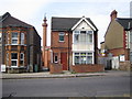
3
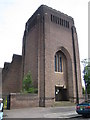
Luton: St Andrew's Church
The massive functional tower of this 1932-built church in Blenheim Crescent is typical of the work of its architect, Giles Gilbert Scott, who was known for his work on such iconic buildings as Battersea Power Station Image and Liverpool Cathedral Image
Image: © Nigel Cox
Taken: 25 Jun 2006
0.16 miles
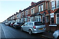
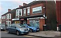
4
Luton: Selbourne Road & Leagrave Road
The terraced houses are on Selbourne Road, and the B579 Leagrave Road passes from lower left to middle right. Note the pole mounted CCTV camera monitoring action outside Anglo Asian Continental Supplies.
Image: © Nigel Cox
Taken: 25 Jun 2006
0.16 miles
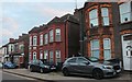
5
Luton: Norman Road
Norman Road runs parallel to Dane Road and Saxon Road, so you know where the street-naming committee were coming from. The 1888 Ordnance Survey map shows this whole area as open farmland.
Image: © Nigel Cox
Taken: 25 Jun 2006
0.19 miles
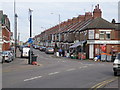
6
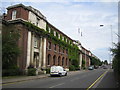
Luton: Britannia House
Originally this large industrial building on Leagrave Road was used by the Swedish ball-bearing manufacturer SKF, and their name can still be seen carved in the stonework at the top of the entrance portico. However it was sold in 1978 and SKF now occupy premises in Sundon Park Road elsewhere in Luton. The building is now used for multi-occupancy business suites.
Image: © Nigel Cox
Taken: 25 Jun 2006
0.20 miles
9
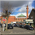
Mosque, Westbourne Road, Bury Park, Luton
It occurred to me that the people had attended Friday prayers.
Image: © Robin Stott
Taken: 24 Feb 2017
0.22 miles
10
Luton: Jamia Masjid Ghousia Mosque
The mosque in Westbourne Road viewed between the houses on Leagrave Road.
Image: © Nigel Cox
Taken: 25 Jun 2006
0.24 miles