IMAGES TAKEN NEAR TO
Kennington Road, LUTON, LU3 1BH
Introduction
This page details the photographs taken nearby to Kennington Road, LU3 1BH by members of the Geograph project.
The Geograph project started in 2005 with the aim of publishing, organising and preserving representative images for every square kilometre of Great Britain, Ireland and the Isle of Man.

There are currently over 7.5m images from over14,400 individuals and you can help contribute to the project by visiting https://www.geograph.org.uk
Image Map
Images are licensed for reuse under creativecommons.org/licenses/by-sa/2.0
Notes
- Clicking on the map will re-center to the selected point.
- The higher the marker number, the further away the image location is from the centre of the postcode.
Image Listing (4 Images Found)
Images are licensed for reuse under creativecommons.org/licenses/by-sa/2.0
Image
Details
Distance
1
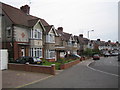
Luton: Carlton Crescent
Typical 1930s housing in the Biscot area of north Luton.
Image: © Nigel Cox
Taken: 25 Jun 2006
0.14 miles
2
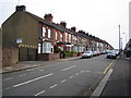
Luton: Norman Road
Norman Road runs parallel to Dane Road and Saxon Road, so you know where the street-naming committee were coming from. The 1888 Ordnance Survey map shows this whole area as open farmland.
Image: © Nigel Cox
Taken: 25 Jun 2006
0.20 miles
3
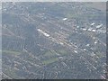
0742 Looking south from over Leagrave towards Luton town centre
The Bedford-Brighton railway follows the obvious line from bottom right to top left.
Image: © M J Richardson
Taken: 21 Apr 2010
0.22 miles
4
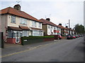
Luton: Fitzroy Avenue
1930s housing development off Leagrave Road.
Image: © Nigel Cox
Taken: 25 Jun 2006
0.23 miles