IMAGES TAKEN NEAR TO
Wenlock Street, LUTON, LU2 0NH

Introduction

This page details the photographs taken nearby to Wenlock Street, LU2 0NH by members of the Geograph project.

The Geograph project started in 2005 with the aim of publishing, organising and preserving representative images for every square kilometre of Great Britain, Ireland and the Isle of Man.

There are currently over 7.5m images from over14,400 individuals and you can help contribute to the project by visiting https://www.geograph.org.uk

Image Map


Images are licensed for reuse under creativecommons.org/licenses/by-sa/2.0
Notes
  • Clicking on the map will re-center to the selected point.
  • The higher the marker number, the further away the image location is from the centre of the postcode.

Image Listing (81 Images Found)

Images are licensed for reuse under creativecommons.org/licenses/by-sa/2.0
  • ...
Image
Details
Distance
1
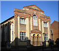
Luton: High Town Methodist Church (1)
This is the former Primitive Methodist Chapel built in 1897 on the north west side of High Town Road. It is one of an adjacent pair of chapels, which, I think, now form the High Town Methodist Church.
Image: © Nigel Cox Taken: 23 Jan 2007
0.05 miles
2
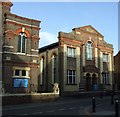
Luton: High Town Methodist Church (2)
This is one of a pair of adjacent chapels on the north-west side of High Town Road which, I think, now form the High Town Methodist Church. The tablet in the upper triangular pediment reads: CHAPEL 1852
Image: © Nigel Cox Taken: 23 Jan 2007
0.05 miles
3
High Town Methodist Church
On High Town Road, viewed from Duke Street.
Image: © Thomas Nugent Taken: 9 Dec 2008
0.08 miles
4
The Railway Tavern
On High Town Road at Midland Road, near Luton railway station.
Image: © Thomas Nugent Taken: 18 Nov 2011
0.09 miles
5
High Town Methodist Church
On High Town Road, at Duke Street.
Image: © Thomas Nugent Taken: 26 Nov 2009
0.09 miles
6
Luton: High Town Road
This street is the focal point of one of Luton's three commercial Conservation Areas. The top of the tower of the High Town Methodist Church in Image is just visible over the roofs to the right.
Image: © Nigel Cox Taken: 23 Jan 2007
0.09 miles
7
Offices and flats on Old Bedford Road
The facade of this 1929 building has been retained but what can be the excuse for the three floors and penthouse above?
Image: © John M Taken: 19 May 2009
0.10 miles
8
Derelict building outside the Station Car Park
Image: © John M Taken: 19 May 2009
0.10 miles
9
Railway Tavern
Pub on the corner of High Town Road and Midland Road, opposite the railway station.
Image: © Thomas Nugent Taken: 9 Dec 2008
0.11 miles
10
St Matthew's Church
Note the Celtic cross above the door. See also Image
Image: © Thomas Nugent Taken: 26 Nov 2009
0.11 miles
  • ...