1
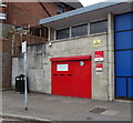
Royal Mail offices on Dunstable Road, Luton
Image: © David Howard
Taken: 9 Jan 2022
0.01 miles
2
Postboxes, Luton Sorting Office, Dunstable Road
Postbox No. LU1 231.
Image: © JThomas
Taken: 3 Aug 2019
0.02 miles
3
Royal Mail Delivery Office
Built 1957 to the designs of Ministry of Works architect Thomas Winterburn. Greatly influenced by the prevailing modernist architecture of the day (inspired by the work of Swiss architect Le Corbusier).
Image: © Jim Osley
Taken: 21 Mar 2015
0.02 miles
4
Date stone, Luton Delivery Office
Plaques of this kind are often to be found on public service buildings designed by architects in the Office of Works, and its successors, the Ministry of Works, and the Ministry of Public Building and Works.
Image: © Jim Osley
Taken: 21 Mar 2015
0.02 miles
5
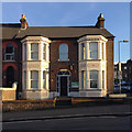
Five shops with flats above, formerly Victoria Villas, 8-16 Dunstable Road, Luton
The older 3-storey block in the centre of the photo is named rather oddly Victoria Villas on a 1:500 map of 1880. It appears to have always been so, and has not changed since apart from the insertion of shops, the nearest of which is on the corner of Cardigan Street. There were a further five properties immediately to the northwest named Brighton Terrace, nos 12-26, houses with long rear extensions. They appear to have been replaced by 20th-century development perhaps as a result of the widening and re-alignment of Dunstable Road. The view is from the pedestrian crossing at Inkerman Street and Cardiff Road.
Image: © Robin Stott
Taken: 24 Feb 2017
0.04 miles
6
Samaritans, top of Cardiff Road, Luton
Decorative relief panels below windows are an eyecatching feature of older houses.
Image: © Robin Stott
Taken: 24 Feb 2017
0.07 miles
7
Luton: Guru Nanak Gurdwara Sikh Temple
A former school building in Dallow Road converted for use as a Sikh Temple. The Temple's website is here http://www.gngluton.com/
Image: © Nigel Cox
Taken: 25 Jun 2006
0.10 miles
8
Junction of Telford Way and Dunstable Road
Image: © David Howard
Taken: 17 Aug 2011
0.13 miles
9
Luton: Footbridge over the ring road
The three-armed footbridge is a well-known landmark to anyone who has driven around Luton's ring road, and shows up nicely on the Ordnance Survey 1:25,000 scale mapping...
Image: © Nigel Cox
Taken: 25 Jun 2006
0.14 miles
10
Lennon Court, Downs Road, Luton
Thanks to old maps it can be seen that these stepped blocks of flats with their heavy balconies were built on the site of 54 Napier Road and the side garden of No 1 Downs Road
Image They first appear in part on an OS map of 1986.
Image: © Robin Stott
Taken: 24 Feb 2017
0.15 miles


