IMAGES TAKEN NEAR TO
Priestleys, LUTON, LU1 5QJ
Introduction
This page details the photographs taken nearby to Priestleys, LU1 5QJ by members of the Geograph project.
The Geograph project started in 2005 with the aim of publishing, organising and preserving representative images for every square kilometre of Great Britain, Ireland and the Isle of Man.

There are currently over 7.5m images from over14,400 individuals and you can help contribute to the project by visiting https://www.geograph.org.uk
Image Map
Images are licensed for reuse under creativecommons.org/licenses/by-sa/2.0
Notes
- Clicking on the map will re-center to the selected point.
- The higher the marker number, the further away the image location is from the centre of the postcode.
Image Listing (8 Images Found)
Images are licensed for reuse under creativecommons.org/licenses/by-sa/2.0
Image
Details
Distance
2
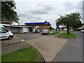
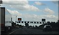
Service station on Whipperley Ring, Farley Hill, Luton
Image: © JThomas
Taken: 3 Aug 2019
0.15 miles
4
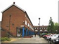
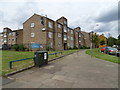
Luton: Market Square, Farley Hill
Farley Hill is a large post-war housing estate built on the fields to the north of the former Farley Farm. Market Square is the main community shopping area.
Image: © Nigel Cox
Taken: 16 May 2008
0.21 miles
6
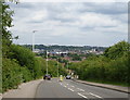
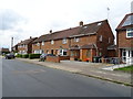
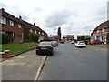
Long Croft Road
Downhill towards Luton centre.
Image: © JThomas
Taken: 3 Aug 2019
0.23 miles
8
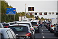
Motorway closure, M1 Luton
Total closure of the M1 southbound due to a police incident at Junction 10, lasting about an hour.
Image: © David Martin
Taken: 12 Sep 2020
0.25 miles