IMAGES TAKEN NEAR TO
Bretts Mead, LUTON, LU1 5NH
Introduction
This page details the photographs taken nearby to Bretts Mead, LU1 5NH by members of the Geograph project.
The Geograph project started in 2005 with the aim of publishing, organising and preserving representative images for every square kilometre of Great Britain, Ireland and the Isle of Man.

There are currently over 7.5m images from over14,400 individuals and you can help contribute to the project by visiting https://www.geograph.org.uk
Image Map
Images are licensed for reuse under creativecommons.org/licenses/by-sa/2.0
Notes
- Clicking on the map will re-center to the selected point.
- The higher the marker number, the further away the image location is from the centre of the postcode.
Image Listing (16 Images Found)
Images are licensed for reuse under creativecommons.org/licenses/by-sa/2.0
Image
Details
Distance
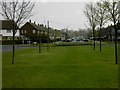
6
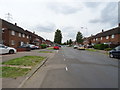
Luton: Whipperley Way, Farley Hill
A post-war housing estate road built on a truly epic scale, Whipperley Way is on the Farley Hill estate, named after the nearby former Farley Farm on whose land it was constructed.
Image: © Nigel Cox
Taken: 16 May 2008
0.19 miles
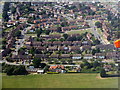
7

Stockwood Park from the air
A snow covered park, viewed from a Luton bound flight from Glasgow.
Image: © Thomas Nugent
Taken: 11 Feb 2013
0.20 miles
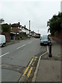
8

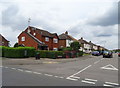
Luton: Farley Hill Methodist Church
When the Farley Hill Estate was laid out the designers considered the pastoral needs of the population and two churches were built at either end of the road in the estate called Santingfield. This is the Methodist Church, built in North Drift Way at its junction with Santingfield North. See Image for the other church.
Image: © Nigel Cox
Taken: 16 May 2008
0.22 miles
9
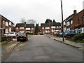
Luton - houses at Farley Hill
The central green is Farm Green, surrounded by Farley Farm Road, Hagdell Road and Homestead Way. The nearest road is Farley Hill [B4540].
Image: © M J Richardson
Taken: 11 Jul 2013
0.22 miles
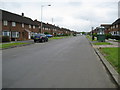
10
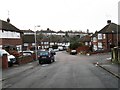
Looking from Farley Hill into Wilsden Avenue
Image: © Basher Eyre
Taken: 8 Sep 2011
0.22 miles