IMAGES TAKEN NEAR TO
Farley Fields, LUTON, LU1 5FJ
Introduction
This page details the photographs taken nearby to Farley Fields, LU1 5FJ by members of the Geograph project.
The Geograph project started in 2005 with the aim of publishing, organising and preserving representative images for every square kilometre of Great Britain, Ireland and the Isle of Man.

There are currently over 7.5m images from over14,400 individuals and you can help contribute to the project by visiting https://www.geograph.org.uk
Image Map
Images are licensed for reuse under creativecommons.org/licenses/by-sa/2.0
Notes
- Clicking on the map will re-center to the selected point.
- The higher the marker number, the further away the image location is from the centre of the postcode.
Image Listing (19 Images Found)
Images are licensed for reuse under creativecommons.org/licenses/by-sa/2.0
Image
Details
Distance
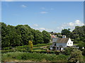
1
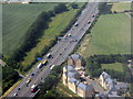
New houses at Farleygreen
Handy for the M1. I wonder how the yield of the solar panels is divided between the multiple occupants.
Image: © M J Richardson
Taken: 11 Jul 2013
0.00 miles
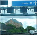

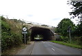
4
Central Bedfordshire : M1 Motorway
The M1 Motorway seen between Junction 11 and Junction 10 (Pepperstock).
Image: © Lewis Clarke
Taken: 25 Mar 2018
0.04 miles
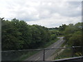
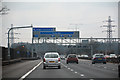
8

Central Bedfordshire : M1 Motorway
The M1 Motorway seen between Junction 11 and Junction 10 (Pepperstock).
Image: © Lewis Clarke
Taken: 3 Oct 2018
0.11 miles
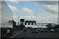
10
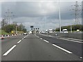
Power lines cross the M1 north of junction 10.
Image: © Peter Whatley
Taken: 3 Apr 2012
0.16 miles