IMAGES TAKEN NEAR TO
Mossman Drive, LUTON, LU1 4EX
Introduction
This page details the photographs taken nearby to Mossman Drive, LU1 4EX by members of the Geograph project.
The Geograph project started in 2005 with the aim of publishing, organising and preserving representative images for every square kilometre of Great Britain, Ireland and the Isle of Man.

There are currently over 7.5m images from over14,400 individuals and you can help contribute to the project by visiting https://www.geograph.org.uk
Image Map
Images are licensed for reuse under creativecommons.org/licenses/by-sa/2.0
Notes
- Clicking on the map will re-center to the selected point.
- The higher the marker number, the further away the image location is from the centre of the postcode.
Image Listing (24 Images Found)
Images are licensed for reuse under creativecommons.org/licenses/by-sa/2.0
Image
Details
Distance
1
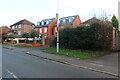
Caddington from the air
Looking along Elm Avenue to its T-junction with Manor Road, with The Crescent going off to the right and The Dell on the left.
Image: © M J Richardson
Taken: 11 Jul 2013
0.03 miles
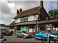
4

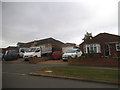
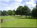
The Vehicle Centre on Manor Road, Caddington
Image: © David Howard
Taken: 19 Jul 2017
0.10 miles
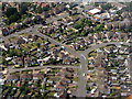
6
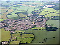
Caddington from above Slip End
Seen from the air about one minute after leaving Luton Airport.
Image: © M J Richardson
Taken: 29 Jun 2015
0.16 miles
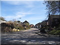
8
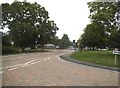
Manor Road at the junction of Dunstable Road
The cobbles are less than a year old.
Image: © David Howard
Taken: 19 Jul 2017
0.16 miles