IMAGES TAKEN NEAR TO
Dallow Road, LUTON, LU1 1TD
Introduction
This page details the photographs taken nearby to Dallow Road, LU1 1TD by members of the Geograph project.
The Geograph project started in 2005 with the aim of publishing, organising and preserving representative images for every square kilometre of Great Britain, Ireland and the Isle of Man.

There are currently over 7.5m images from over14,400 individuals and you can help contribute to the project by visiting https://www.geograph.org.uk
Image Map
Images are licensed for reuse under creativecommons.org/licenses/by-sa/2.0
Notes
- Clicking on the map will re-center to the selected point.
- The higher the marker number, the further away the image location is from the centre of the postcode.
Image Listing (1 Images Found)
Images are licensed for reuse under creativecommons.org/licenses/by-sa/2.0
Image
Details
Distance
1
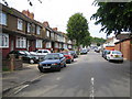
Luton: Runley Road
The 1888 Ordnance Survey map shows this area as Runley Woods, whilst the 1940s Ordnance Survey mapping shows this estate as a dead end off Dallow Road. Post-Second World War developments have seen Runley Road extended north-westwards back onto Dallow Road. The northern edge and slopes of The Chilterns are immediately behind the houses to the left.
Image: © Nigel Cox
Taken: 25 Jun 2006
0.17 miles