IMAGES TAKEN NEAR TO
Clark Mount, LEEDS, LS9 8QB
Introduction
This page details the photographs taken nearby to Clark Mount, LS9 8QB by members of the Geograph project.
The Geograph project started in 2005 with the aim of publishing, organising and preserving representative images for every square kilometre of Great Britain, Ireland and the Isle of Man.

There are currently over 7.5m images from over14,400 individuals and you can help contribute to the project by visiting https://www.geograph.org.uk
Image Map
Images are licensed for reuse under creativecommons.org/licenses/by-sa/2.0
Notes
- Clicking on the map will re-center to the selected point.
- The higher the marker number, the further away the image location is from the centre of the postcode.
Image Listing (182 Images Found)
Images are licensed for reuse under creativecommons.org/licenses/by-sa/2.0
Image
Details
Distance
4
Back Kitson Street - Pontefract Lane
Image: © Betty Longbottom
Taken: 8 Apr 2009
0.03 miles

6
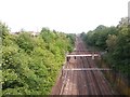
Railway cutting east of Pontefract Lane, Leeds
Four running lines, and at left the end of a freight loop as can be seen more clearly in Image
Image: © Stephen Craven
Taken: 9 Jun 2016
0.04 miles