IMAGES TAKEN NEAR TO
Neptune Street, LEEDS, LS9 8PB
Introduction
This page details the photographs taken nearby to Neptune Street, LS9 8PB by members of the Geograph project.
The Geograph project started in 2005 with the aim of publishing, organising and preserving representative images for every square kilometre of Great Britain, Ireland and the Isle of Man.

There are currently over 7.5m images from over14,400 individuals and you can help contribute to the project by visiting https://www.geograph.org.uk
Image Map
Images are licensed for reuse under creativecommons.org/licenses/by-sa/2.0
Notes
- Clicking on the map will re-center to the selected point.
- The higher the marker number, the further away the image location is from the centre of the postcode.
Image Listing (531 Images Found)
Images are licensed for reuse under creativecommons.org/licenses/by-sa/2.0
Image
Details
Distance
2
Roberts Wharf, River Aire
Converted warehouse viewed from the tower of the Royal Armouries.
Image: © David Dixon
Taken: 24 May 2013
0.02 miles
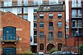
3
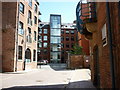
Quay One, Neptune Street, Leeds
A contemporary style of architecture, the steel-clad building resting on very obvious steel girders.
Image: © Stephen Craven
Taken: 18 Feb 2017
0.02 miles
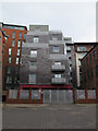
4
Old mill - Leeds
Now obviously converted to accommodation with balconies. Photographed from by the Royal Armouries.
Image: © Chris Allen
Taken: 26 Aug 2001
0.02 miles
6
Footbridge over the Aire and Canal
I am pretty sure the bridge is in SE3033, but not sure about the photographer's position. It's a close call. Could do with a GPS.
Image: © Mick Garratt
Taken: 12 Feb 2007
0.03 miles
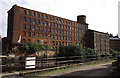
7
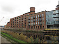
Bank Mills (B and D blocks)
This pair of buildings comprised part of a flax mill (one of many in south Leeds) B block was built 1831-32 by John Clark of Edinburgh who also designed nearby Hunslet Mill; D block with the tower was added 1856 and extended 1888. Now grade 2 listed (list entry 1375363) and unlike Hunslet Mill, converted for residential use.
Image: © Stephen Craven
Taken: 29 Oct 2016
0.04 miles
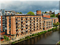
8

Roberts Wharf on the River Aire in Leeds
Completed in 2006, the Roberts Wharf includes the refurbished Grade II listed Bank Mills, converted into apartments.
Image: © Mat Fascione
Taken: 4 Aug 2017
0.04 miles
9

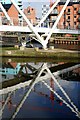
River Aire, Leeds Lock and Knight's Way Bridge
Leeds Lock drops boats down 4 feet 6 inches. The lock, like all the locks on the Aire and Calder, is operated mechanically. There are lock keepers who move up and down the system but all locks can be self-operated. The lock has traffic lights to control the use of the lock.
Behind the lock is Knight's Way Bridgewhich was opened in 2007. It links the Royal Armouries museum with Marsh Lane.
Image: © David Dixon
Taken: 24 May 2013
0.04 miles
10

Name that bridge..it's now called Knight's Way Bridge
New (2006) bridge across the River Aire now the subject of a competition to name that bridge. Now named, quote from Pennine waterway's website.
'5th November 2007, British Waterways invited suggestions for a name from local communities, schoolchildren or individuals.
The winning name was thought up by ten-year old Maria Anderson, from Leeds, and will appear on a plaque to be mounted on the bridge.
The winning name - Knight's Way Bridge - won the votes of the panel of judges, made up of representatives from British Waterways, Leeds City Council, The Clarence Dock Company Ltd and the Royal Armouries Museum. Maria thought of the name because it was close to the Royal Armouries Museum.'
Image: © Steve Fareham
Taken: 23 Oct 2007
0.04 miles