IMAGES TAKEN NEAR TO
Long Close Lane, LEEDS, LS9 8NP
Introduction
This page details the photographs taken nearby to Long Close Lane, LS9 8NP by members of the Geograph project.
The Geograph project started in 2005 with the aim of publishing, organising and preserving representative images for every square kilometre of Great Britain, Ireland and the Isle of Man.

There are currently over 7.5m images from over14,400 individuals and you can help contribute to the project by visiting https://www.geograph.org.uk
Image Map
Images are licensed for reuse under creativecommons.org/licenses/by-sa/2.0
Notes
- Clicking on the map will re-center to the selected point.
- The higher the marker number, the further away the image location is from the centre of the postcode.
Image Listing (188 Images Found)
Images are licensed for reuse under creativecommons.org/licenses/by-sa/2.0
Image
Details
Distance
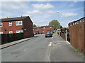
1
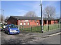
Richmond Hill Community Centre - Long Close Lane
Image: © Betty Longbottom
Taken: 31 Mar 2008
0.01 miles
2
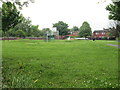
Recreation Area - off Walter Crescent
Image: © Betty Longbottom
Taken: 29 May 2013
0.04 miles
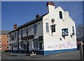
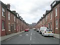
3

Back Dent Street - Pontefract Avenue
Image: © Betty Longbottom
Taken: 8 Apr 2009
0.04 miles
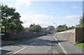
5
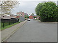
Walter Crescent - looking towards Upper Accommodation Road
Image: © Betty Longbottom
Taken: 29 May 2013
0.05 miles
9
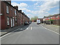
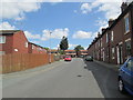
Dent Street - viewed from Kippax Mount
Image: © Betty Longbottom
Taken: 3 Jun 2013
0.06 miles
10
Dent Street - viewed from Kippax Mount
Image: © Betty Longbottom
Taken: 3 Jun 2013
0.06 miles