IMAGES TAKEN NEAR TO
Mill Street, LEEDS, LS9 8BP
Introduction
This page details the photographs taken nearby to Mill Street, LS9 8BP by members of the Geograph project.
The Geograph project started in 2005 with the aim of publishing, organising and preserving representative images for every square kilometre of Great Britain, Ireland and the Isle of Man.

There are currently over 7.5m images from over14,400 individuals and you can help contribute to the project by visiting https://www.geograph.org.uk
Image Map
Images are licensed for reuse under creativecommons.org/licenses/by-sa/2.0
Notes
- Clicking on the map will re-center to the selected point.
- The higher the marker number, the further away the image location is from the centre of the postcode.
Image Listing (610 Images Found)
Images are licensed for reuse under creativecommons.org/licenses/by-sa/2.0
Image
Details
Distance
1
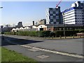
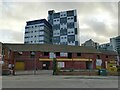
Richmond Hill Ambulance Station - Flax Place
Image: © Betty Longbottom
Taken: 31 Mar 2008
0.01 miles
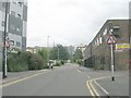
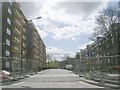
3
Mill Street
The road originally served Bank Low woollen mill.
Image: © Stephen Craven
Taken: 29 Jan 2022
0.03 miles

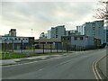
10
Vacant premises, Saxton Lane
I suspect these are scheduled for demolition and redevelopment as city centre regeneration spreads to this part of Leeds.
Image: © Stephen Craven
Taken: 29 Jan 2022
0.06 miles