
IMAGES TAKEN NEAR TO
Merchants Quay, East Street, LEEDS, LS9 8BB
Introduction
This page details the photographs taken nearby to Merchants Quay, East Street, LS9 8BB by members of the Geograph project.
The Geograph project started in 2005 with the aim of publishing, organising and preserving representative images for every square kilometre of Great Britain, Ireland and the Isle of Man.

There are currently over 7.5m images from over14,400 individuals and you can help contribute to the project by visiting https://www.geograph.org.uk
Image Map
Images are licensed for reuse under creativecommons.org/licenses/by-sa/2.0
Notes
- Clicking on the map will re-center to the selected point.
- The higher the marker number, the further away the image location is from the centre of the postcode.
Image Listing (874 Images Found)
Images are licensed for reuse under creativecommons.org/licenses/by-sa/2.0
Image
Details
Distance
1

New Turquoise Building in Leeds.
Leeds is rapidly expanding and I'm not too sure if I like the colour scheme. Looking across from the top floor of York Street car park.
Image: © Steve Partridge
Taken: 3 Dec 2006
0.01 miles


4

Merchants Quay, Leeds
Looking across the River Aire to Merchants Quay in Leeds city centre. Crown Point bridge reflected in the river. In the distance, Leeds city church.
Image: © I Love Colour
Taken: 7 Mar 2023
0.03 miles
5
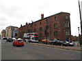
The Chandlers, Crown Point Road, Leeds
Traffic was particularly busy coming off Crown Point bridge towards the city centre. The building across the road is "The Chandlers", formerly a stables and horse feed warehouse, built 1876, converted c1985 into flats, and grade 2 listed (list entry 1255931).
Image: © Stephen Craven
Taken: 29 Oct 2016
0.03 miles
6

Plaque for William Turton, The Calls, Leeds
See Image for context.
Image: © Stephen Craven
Taken: 14 Mar 2016
0.03 miles
7

The Chandlers, Crown Point Road, Leeds - detail
For a wider view of this grade 2 listed former stables and warehouse, see Image The tower shown here is "reputed to contain a spiral stair and with an ornate iron railing to viewing platform, possibly a former chimney flue" according to the listing.
Image: © Stephen Craven
Taken: 29 Oct 2016
0.03 miles
8

Crown Point bridge Leeds
Crossing the River Aire in Leeds.The bridge was opened on 9th July 1873 originally as a toll bridge. The bridge was widened in 1994.
Image: © Steve Fareham
Taken: 23 Oct 2007
0.03 miles
9
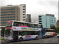
Bus and coach entering Leeds
Among the traffic entering the city centre on the A61 were a First bus on route 2 from Middleton to Roundhay (though there appeared to be no passengers on board) and a Stagecoach service near the end of its journey from Hull.
Image: © Stephen Craven
Taken: 29 Oct 2016
0.03 miles
10

William Turton's buildings, The Calls, Leeds
The building dates from 1876, originally a horse feed store (as hinted at by the carved horse's head over the archway) but now converted to flats and called The Chandlers. Listed grade 2 (list entry 1255931). See Image for a wider view.
Image: © Stephen Craven
Taken: 14 Mar 2016
0.03 miles