IMAGES TAKEN NEAR TO
Coldcotes View, LEEDS, LS9 6QP
Introduction
This page details the photographs taken nearby to Coldcotes View, LS9 6QP by members of the Geograph project.
The Geograph project started in 2005 with the aim of publishing, organising and preserving representative images for every square kilometre of Great Britain, Ireland and the Isle of Man.

There are currently over 7.5m images from over14,400 individuals and you can help contribute to the project by visiting https://www.geograph.org.uk
Image Map
Images are licensed for reuse under creativecommons.org/licenses/by-sa/2.0
Notes
- Clicking on the map will re-center to the selected point.
- The higher the marker number, the further away the image location is from the centre of the postcode.
Image Listing (61 Images Found)
Images are licensed for reuse under creativecommons.org/licenses/by-sa/2.0
Image
Details
Distance
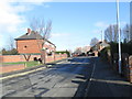
1
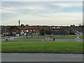
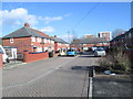
Shops on Coldcotes Close
The parade of shops forms part of this 1930s housing estate.
Image: © Stephen Craven
Taken: 5 Feb 2023
0.03 miles
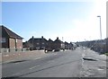
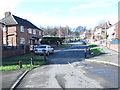
3
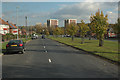
Coldcotes Crescent
Part of a 1930s housing estate with a much more interesting layout of roads than most modern ones.
Image: © Stephen Craven
Taken: 5 Feb 2023
0.05 miles
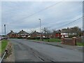
4
Coldcotes Walk - Coldcotes Crescent
Image: © Betty Longbottom
Taken: 4 Feb 2014
0.06 miles
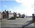
6
Coldcotes Garth - Coldcotes Crescent
Image: © Betty Longbottom
Taken: 4 Feb 2014
0.07 miles
7
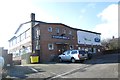
Gipton Working Men's Club - South Farm Road
Image: © Betty Longbottom
Taken: 4 Feb 2014
0.07 miles
9
South Farm Crescent - South Farm Road
Image: © Betty Longbottom
Taken: 4 Feb 2014
0.08 miles
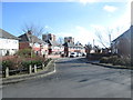
10
Coldcotes Crescent - South Farm Road
Image: © Betty Longbottom
Taken: 4 Feb 2014
0.09 miles