IMAGES TAKEN NEAR TO
Mount Pleasant Avenue, LEEDS, LS8 4EF
Introduction
This page details the photographs taken nearby to Mount Pleasant Avenue, LS8 4EF by members of the Geograph project.
The Geograph project started in 2005 with the aim of publishing, organising and preserving representative images for every square kilometre of Great Britain, Ireland and the Isle of Man.

There are currently over 7.5m images from over14,400 individuals and you can help contribute to the project by visiting https://www.geograph.org.uk
Image Map (Loading...)


Getting Data...Please wait
Leaflet Map data © OpenStreetMap
Images are licensed for reuse under creativecommons.org/licenses/by-sa/2.0
Notes
- Clicking on the map will re-center to the selected point.
- The higher the marker number, the further away the image location is from the centre of the postcode.
Image Listing (117 Images Found)
Images are licensed for reuse under creativecommons.org/licenses/by-sa/2.0
Image
Details
Distance
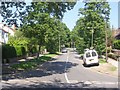
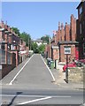
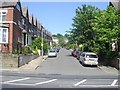
1
Mount Pleasant Avenue - Roundhay Avenue
Image: © Betty Longbottom
Taken: 5 Jun 2013
0.03 miles
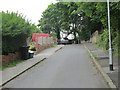
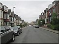
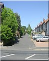
2
Roundhay Avenue - looking towards Cross Roundhay Avenue
Image: © Betty Longbottom
Taken: 5 Jun 2013
0.03 miles
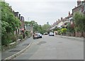
4
Back Roundhay Place - Harehills Lane
Image: © Betty Longbottom
Taken: 1 Jun 2009
0.06 miles
5
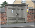
Electricity Substation No 2714 - Cross Roundhay Avenue
Image: © Betty Longbottom
Taken: 5 Jun 2013
0.07 miles
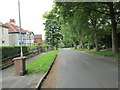
6
Roundhay Crescent - looking towards Cross Roundhay Avenue
Image: © Betty Longbottom
Taken: 5 Jun 2013
0.07 miles
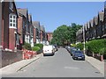
9
Back Roundhay View - Harehills Lane
Image: © Betty Longbottom
Taken: 1 Jun 2009
0.08 miles