IMAGES TAKEN NEAR TO
Elmete Way, LEEDS, LS8 2NB
Introduction
This page details the photographs taken nearby to Elmete Way, LS8 2NB by members of the Geograph project.
The Geograph project started in 2005 with the aim of publishing, organising and preserving representative images for every square kilometre of Great Britain, Ireland and the Isle of Man.

There are currently over 7.5m images from over14,400 individuals and you can help contribute to the project by visiting https://www.geograph.org.uk
Image Map (Loading...)


Getting Data...Please wait
Leaflet Map data © OpenStreetMap
Images are licensed for reuse under creativecommons.org/licenses/by-sa/2.0
Notes
- Clicking on the map will re-center to the selected point.
- The higher the marker number, the further away the image location is from the centre of the postcode.
Image Listing (76 Images Found)
Images are licensed for reuse under creativecommons.org/licenses/by-sa/2.0
Image
Details
Distance
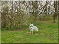
2
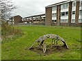
Metal insect
One of several metal animal figures around this housing estate.
Image: © Stephen Craven
Taken: 26 Mar 2023
0.03 miles
3
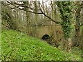
Footbridge over a beck
The bridge takes a path off Easterly Road Image over an unnamed beck.
Image: © Stephen Craven
Taken: 26 Mar 2023
0.03 miles
4
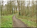
Path off Easterly Road
The path connects housing on Asket Hill with the main A58 and its bus stops.
Image: © Stephen Craven
Taken: 26 Mar 2023
0.04 miles
5
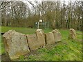
Carved hare
One of several animal figures around this housing estate, this one carved in a stone. Beyond is an unfenced basketball court.
Image: © Stephen Craven
Taken: 26 Mar 2023
0.05 miles
6
Metal owl
One of several metal animal figures around this housing estate.
Image: © Stephen Craven
Taken: 26 Mar 2023
0.05 miles

8

Asket Hill, looking down towards Wetherby Road
Asket Hill is an ancient route but the road now mainly serves a housing estate occupying the former grounds of Asket Hall.
Image: © Stephen Craven
Taken: 7 Jul 2018
0.07 miles
9
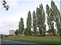
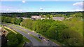
Poplars by the A58
A row of tall poplars seen across the Easterly Road dual carriageway, with Barncroft Court the tower block on the left.
Image: © Derek Harper
Taken: 29 Jul 2011
0.07 miles
10
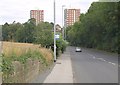
Wetherby Road
The road dropping to cross a stream and meet the A58, with two of the four Barncroft blocks of flats beyond; only the left one, Barncroft Heights, is in square.
Image: © Derek Harper
Taken: 29 Jul 2011
0.08 miles