IMAGES TAKEN NEAR TO
Talbot Road, LEEDS, LS8 1AG
Introduction
This page details the photographs taken nearby to Talbot Road, LS8 1AG by members of the Geograph project.
The Geograph project started in 2005 with the aim of publishing, organising and preserving representative images for every square kilometre of Great Britain, Ireland and the Isle of Man.

There are currently over 7.5m images from over14,400 individuals and you can help contribute to the project by visiting https://www.geograph.org.uk
Image Map (Loading...)


Getting Data...Please wait
Leaflet Map data © OpenStreetMap
Images are licensed for reuse under creativecommons.org/licenses/by-sa/2.0
Notes
- Clicking on the map will re-center to the selected point.
- The higher the marker number, the further away the image location is from the centre of the postcode.
Image Listing (93 Images Found)
Images are licensed for reuse under creativecommons.org/licenses/by-sa/2.0
Image
Details
Distance
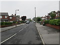
2
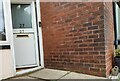
Rounday, Talbot Road
This is the north facing wall of 27 Talbot Road, and there is a benchmark cut into the 4th and 5th brick course.
Image: © Mel Towler
Taken: 14 Aug 2021
0.02 miles
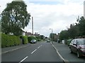
4
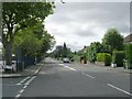
Talbot Road - looking towards Street Lane
Image: © Betty Longbottom
Taken: 21 Jun 2013
0.06 miles
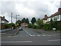
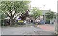
5
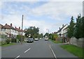
Talbot Road - viewed from East Moor Road
Image: © Betty Longbottom
Taken: 17 Aug 2009
0.06 miles
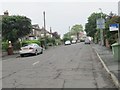
8
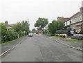
Talbot Grove - looking towards Street Lane
Image: © Betty Longbottom
Taken: 21 Jun 2013
0.08 miles
9
Talbot Primary School - East Moor Road
Image: © Betty Longbottom
Taken: 21 Jun 2013
0.08 miles
10
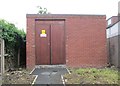
Electricity Substation No 3494 - East Moor Crescent
Image: © Betty Longbottom
Taken: 21 Jun 2013
0.08 miles