IMAGES TAKEN NEAR TO
Norfolk Walk, LEEDS, LS7 4PS
Introduction
This page details the photographs taken nearby to Norfolk Walk, LS7 4PS by members of the Geograph project.
The Geograph project started in 2005 with the aim of publishing, organising and preserving representative images for every square kilometre of Great Britain, Ireland and the Isle of Man.

There are currently over 7.5m images from over14,400 individuals and you can help contribute to the project by visiting https://www.geograph.org.uk
Image Map (Loading...)


Getting Data...Please wait
Leaflet Map data © OpenStreetMap
Images are licensed for reuse under creativecommons.org/licenses/by-sa/2.0
Notes
- Clicking on the map will re-center to the selected point.
- The higher the marker number, the further away the image location is from the centre of the postcode.
Image Listing (232 Images Found)
Images are licensed for reuse under creativecommons.org/licenses/by-sa/2.0
Image
Details
Distance
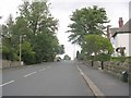
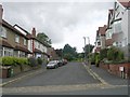
2
Allerton Park, Chapel Allerton
From its junction with Gledhow Lane.
Image: © Rich Tea
Taken: 8 Apr 2006
0.05 miles
3
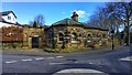
Manor Lodge, Gledhow Lane, Chapel Allerton, Leeds
Image: © Mark Stevenson
Taken: 23 Feb 2016
0.05 miles
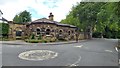
4
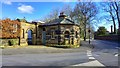
Manor Lodge, Gledhow Lane, Chapel Allerton, Leeds
Image: © Mark Stevenson
Taken: 23 Feb 2016
0.05 miles
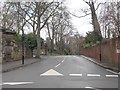
9
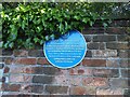
Blue plaque on Gledhow Lane
The plaque gives the history of Chapel Allerton Hall, which still stands behind this brick wall Image
Image: © Stephen Craven
Taken: 30 May 2021
0.06 miles
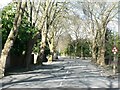
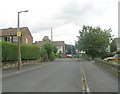
10
Woodland Lane - viewed from Church Lane
Image: © Betty Longbottom
Taken: 1 Feb 2013
0.06 miles