IMAGES TAKEN NEAR TO
Harrogate Road, LEEDS, LS7 3LN
Introduction
This page details the photographs taken nearby to Harrogate Road, LS7 3LN by members of the Geograph project.
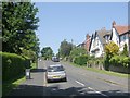
The Geograph project started in 2005 with the aim of publishing, organising and preserving representative images for every square kilometre of Great Britain, Ireland and the Isle of Man.

There are currently over 7.5m images from over14,400 individuals and you can help contribute to the project by visiting https://www.geograph.org.uk
Image Map
Images are licensed for reuse under creativecommons.org/licenses/by-sa/2.0
Notes
- Clicking on the map will re-center to the selected point.
- The higher the marker number, the further away the image location is from the centre of the postcode.
Image Listing (128 Images Found)
Images are licensed for reuse under creativecommons.org/licenses/by-sa/2.0
Image
Details
Distance
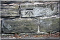
1
Benchmark on #1 Potternewton Lane
Ordnance Survey cut mark benchmark described on the Bench Mark Database at http://www.bench-marks.org.uk/bm64409
Image: © Roger Templeman
Taken: 2 Jun 2016
0.02 miles
2
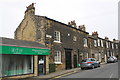
Accountants Offices and houses, Potternewton Lane
There is an OS benchmark Image on a stone in the wall of the nearest house between its two doors
Image: © Roger Templeman
Taken: 2 Jun 2016
0.02 miles
3
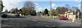
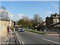
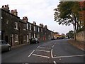
Junction of Harrogate Road and Harehills Lane, Chapel Allerton
Looking north from the traffic island in the centre of Harrogate Road.
Potternewton Lane is out of sight to the left, where the white van is turning. Harrogate Road ahead to the left, King George Avenue ahead in the centre, and Harehills Lane on the right.
The stone structure on the right is the old gateway to the former Chapel Allerton Hospital.
Image: © Rich Tea
Taken: 29 Apr 2006
0.03 miles
4
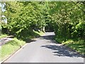
Gledhow Park Drive - Harrogate Road
Image: © Betty Longbottom
Taken: 1 Jun 2009
0.03 miles
5
King George Avenue - Harrogate Road
Image: © Betty Longbottom
Taken: 1 Jun 2009
0.04 miles
6
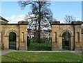
Gates of former Chapel Allerton Hospital
The old Chapel Allerton Hospital site has been redeveloped as housing. The gates are grade 2 listed. For a picture taken in 1938, and more information see the Leodis website http://www.leodis.net/display.aspx?ID=2002815_7455080&DISPLAY=FULL
Image: © Rich Tea
Taken: 29 Apr 2006
0.04 miles
7
Benchmark on wall outside Savile House, Harrogate Road
Ordnance Survey cut mark benchmark described on the Bench Mark Database at http://www.bench-marks.org.uk/bm76395
Image: © Roger Templeman
Taken: 2 Jun 2016
0.05 miles
8
Harehills Lane, Chapel Allerton
Looking from the junction with Harrogate Road. Local council elections are approaching, hence the signs planted in the central reservation.
On the left is the former entrance to Chapel Allerton Hospital, and beyond it one of the new apartment buildings that have replaced the old hospital.
Image: © Rich Tea
Taken: 29 Apr 2006
0.05 miles
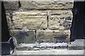
10
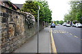
Wall of Harrogate Road, originally the wall of an outbuilding
There is an OS benchmark Image on the 5th stone in the wall from the left hand edge of the image, and two up from the pavement
Image: © Roger Templeman
Taken: 2 Jun 2016
0.05 miles