IMAGES TAKEN NEAR TO
Meanwood Road, LEEDS, LS7 2JE
Introduction
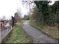
This page details the photographs taken nearby to Meanwood Road, LS7 2JE by members of the Geograph project.
The Geograph project started in 2005 with the aim of publishing, organising and preserving representative images for every square kilometre of Great Britain, Ireland and the Isle of Man.

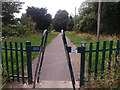
There are currently over 7.5m images from over14,400 individuals and you can help contribute to the project by visiting https://www.geograph.org.uk
Image Map (126 Images)


Leaflet Map data © OpenStreetMap
Images are licensed for reuse under creativecommons.org/licenses/by-sa/2.0
Notes
- Clicking on the map will re-center to the selected point.
- The higher the marker number, the further away the image location is from the centre of the postcode.
Image Listing (126 Images Found)
Images are licensed for reuse under creativecommons.org/licenses/by-sa/2.0
Image
Details
Distance
1
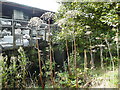
Plant skeletons next to Meanwood Beck, Leeds
I think these are probably dead giant hogweed stems. They are about two metres high.
Image: © Humphrey Bolton
Taken: 15 Oct 2016
0.04 miles
3
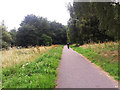
Alwoodley cycle route
A traffic free section in the lower Meawood Valley.
Image: © Stephen Craven
Taken: 21 Jul 2016
0.05 miles
4
Hall & Botterill Ltd, Meanwood Road, Leeds
The company's website describes their business as "the last aluminium foundry remaining in Leeds ... [producing] traditional cast aluminium rainwater goods".
Image: © Stephen Craven
Taken: 23 Jul 2021
0.07 miles
5
A-frame barrier on the Alwoodley cycle route
This type of barrier is becoming more common than the slalom type, but although it may be more effective at deterring motorcyclists, it is no better for pedal cyclists with tricycles, wide handlebars or trailers.
Image: © Stephen Craven
Taken: 21 Jul 2016
0.08 miles
6
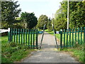
A-frame stile on National Cycle Network Route 668, Leeds
These are carefully designed so as to be too narrow for cycle handlebars, so you have to stop and lift them over the top. This route goes to the northern suburbs of Leeds, alongside King Lane in Alwoodley. This part of the route is on the line of a former mill stream.
Image: © Humphrey Bolton
Taken: 15 Oct 2016
0.08 miles
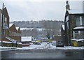
8

Horses and barn at Scott Hall Farm
A surprisingly rural scene only a few hundred metres from the derelict factories of Buslingthorpe, and barely 2km from the centre of Leeds.
Image: © Stephen Craven
Taken: 31 Oct 2015
0.09 miles
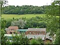
9
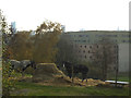
Horses at Scott Hall Farm
A surprisingly rural scene only a few hundred metres from the Education Achievement Academy in the background, and barely 2km from the centre of Leeds whose tall buildings can be seen in the distance.
Image: © Stephen Craven
Taken: 31 Oct 2015
0.09 miles
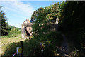
10
Footpath - end of Scott Hall Street
Image: © Betty Longbottom
Taken: 29 Jan 2013
0.09 miles