IMAGES TAKEN NEAR TO
Oatland Gardens, LEEDS, LS7 1SL
Introduction
This page details the photographs taken nearby to Oatland Gardens, LS7 1SL by members of the Geograph project.
The Geograph project started in 2005 with the aim of publishing, organising and preserving representative images for every square kilometre of Great Britain, Ireland and the Isle of Man.

There are currently over 7.5m images from over14,400 individuals and you can help contribute to the project by visiting https://www.geograph.org.uk
Image Map (Loading...)


Getting Data...Please wait
Leaflet Map data © OpenStreetMap
Images are licensed for reuse under creativecommons.org/licenses/by-sa/2.0
Notes
- Clicking on the map will re-center to the selected point.
- The higher the marker number, the further away the image location is from the centre of the postcode.
Image Listing (111 Images Found)
Images are licensed for reuse under creativecommons.org/licenses/by-sa/2.0
Image
Details
Distance
1

Path at rear of Oatland Gardens, Leeds
There is a broad area of grass with trees between this path and Meanwood Road.
This replaces 19C back-to-back houses.
Image: © Humphrey Bolton
Taken: 15 Oct 2016
0.02 miles
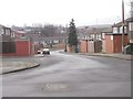
3
Dunbar Business Centre and NCR Route 668, Leeds
Here the Cycle Route runs alongside Meanwood Road.
Image: © Humphrey Bolton
Taken: 15 Oct 2016
0.07 miles
4
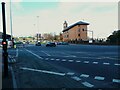
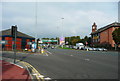
A58 Claypit Lane, Leeds
Part of the complex, and for non-motorists intimidating, Sheepscar Interchange where the A58 and the A61 cross in the Leylands area of Leeds. Note the cycle lane in the foreground and the recently introduced cycle lights, which turn to green a few seconds before the main lights to give cyclists a head start and avoid left-turning traffic.
Image: © Stephen Craven
Taken: 6 Mar 2022
0.07 miles
5
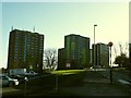
Lovell Park flats, Leeds
These blocks of flats were being refurbished.
Image: © Stephen Craven
Taken: 23 Dec 2015
0.08 miles
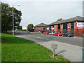
6
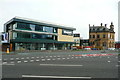
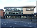
Magnet Kitchens, Leeds
This overlooks an enormous traffic light junction. The prominent dashed lines show the route of National Cycle Route 668.
Image: © Humphrey Bolton
Taken: 15 Oct 2016
0.08 miles
7
Road junction on the north side of central Leeds
This is part of the large junction partly shown in Image Meanwood Road goes to the left, and the A61 and A58 diverge straight ahead.
Image: © Humphrey Bolton
Taken: 15 Oct 2016
0.08 miles
8
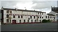
B Balmforth Ltd - Meanwood Road
This was a firm of leather manufacturers.
Image: © Betty Longbottom
Taken: 9 Oct 2007
0.08 miles
9
Magnet Kitchens, Meanwood Road, Leeds
Image: © Stephen Craven
Taken: 6 Mar 2022
0.08 miles