IMAGES TAKEN NEAR TO
Oxford Road, LEEDS, LS7 1PJ
Introduction
This page details the photographs taken nearby to Oxford Road, LS7 1PJ by members of the Geograph project.
The Geograph project started in 2005 with the aim of publishing, organising and preserving representative images for every square kilometre of Great Britain, Ireland and the Isle of Man.

There are currently over 7.5m images from over14,400 individuals and you can help contribute to the project by visiting https://www.geograph.org.uk
Image Map (Loading...)


Getting Data...Please wait
Leaflet Map data © OpenStreetMap
Images are licensed for reuse under creativecommons.org/licenses/by-sa/2.0
Notes
- Clicking on the map will re-center to the selected point.
- The higher the marker number, the further away the image location is from the centre of the postcode.
Image Listing (125 Images Found)
Images are licensed for reuse under creativecommons.org/licenses/by-sa/2.0
Image
Details
Distance
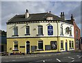
2
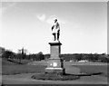
Marsden Monument, Woodhouse Moor, Leeds
Image: © Dr Neil Clifton
Taken: 12 Apr 1990
0.02 miles
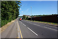
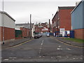
4
Meanwood Road
Meanwood Road near the junction with Cambridge Road, Buslingthorpe, Leeds.
Image: © Chris Heaton
Taken: 13 May 2015
0.05 miles
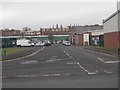
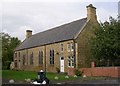
8
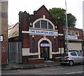
Salvation Army Charity Shop - Meanwood Road
Formerly a church.
Image: © Betty Longbottom
Taken: 9 Oct 2007
0.09 miles
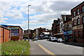
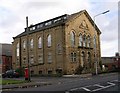
10

#232 Meanwood Road
Former Methodist chapel, now housing John Eckart Photography
Image: © Roger Templeman
Taken: 2 Jun 2016
0.09 miles