IMAGES TAKEN NEAR TO
Sandlewood Crescent, LEEDS, LS6 4RT
Introduction
This page details the photographs taken nearby to Sandlewood Crescent, LS6 4RT by members of the Geograph project.
The Geograph project started in 2005 with the aim of publishing, organising and preserving representative images for every square kilometre of Great Britain, Ireland and the Isle of Man.

There are currently over 7.5m images from over14,400 individuals and you can help contribute to the project by visiting https://www.geograph.org.uk
Image Map
Images are licensed for reuse under creativecommons.org/licenses/by-sa/2.0
Notes
- Clicking on the map will re-center to the selected point.
- The higher the marker number, the further away the image location is from the centre of the postcode.
Image Listing (81 Images Found)
Images are licensed for reuse under creativecommons.org/licenses/by-sa/2.0
Image
Details
Distance
1
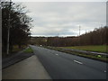
Leeds Ring Road, between Moor Allerton & Adel
Looking West
Image: © Rich Tea
Taken: 1 Jan 2006
0.03 miles
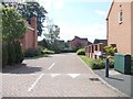
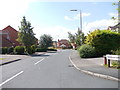
3
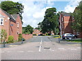
Sandlewood Crescent - Woodlea Lane
Image: © Betty Longbottom
Taken: 19 Jun 2012
0.05 miles
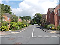
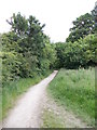
10
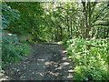
Scotland Mill Lane, near the Tongue Lane end
This used to be the access road from Meanwood to Scotland Mill on the Adel Beck, and Meanwood Farm. The mill has long gone, and the farmhouse is now directly off the Leeds Ring Road that cut the lane off, leaving it as a public bridleway only.
Image: © Stephen Craven
Taken: 5 Jul 2020
0.09 miles